From Seed To Market: How NASA Brings Food To The Table
From Seed to Market: How NASA brings food to the table
Did you know we help farmers grow some of your favorite fruits, veggies and grains?
Our Earth-observing satellites track rainfall amounts, soil moisture, crop health, and more. On the ground, we partner with agencies and organizations around the world to help farmers use that data to care for their fields.
Here are a few ways we help put food on the table, from planting to harvest.
Planting

Did you plant seeds in science class to watch them sprout and grow? They all needed water, right? Our data helps farmers “see” how moist the soil is across large fields.
“When you’re not sure when to water your flowers or your garden, you can look at the soil or touch it with your hands. We are sort of ‘feeling’ the soil, sensing how much water is in the soil – from a satellite,
685 kilometers (408 miles) above Earth,” said John Bolten, the associate program manager of water resources for NASA’s Applied Sciences Program.
This spring, we worked with the U.S. Department of Agriculture and George Mason University to release Crop-CASMA, a tool that shows soil moisture and vegetation conditions for the United States. Able to see smaller areas – about the size of a couple of golf courses – the USDA uses Crop-CASMA to help update farmers on their state’s soil moisture, crop health and growing progress.
Growing

It’s dangerous being a seedling.
Heavy spring rains or summer storms can flood fields and drown growing plants. Dry spells and droughts can starve them of nutrients. Insects and hail can damage them. Farmers need to keep a close eye on plants during the spring and summer months. Our data and programs help them do that.

For example, in California, irrigation is essential for agriculture. California’s Central Valley annually produces more than 250 types of crops and is one of the most productive agricultural regions in the country – but it’s dry. Some parts only get 6 inches of rain per year.
To help, Landsat data powers CropManage – an app that tells farmers how long to irrigate their fields, based on soil conditions and evapotranspiration, or how much water plants are releasing into the atmosphere. The warmer and drier the atmosphere, the more plants “sweat” and lose water that needs to be replenished. Knowing how long to irrigate helps farmers conserve water and be more efficient. In years like 2021, intense droughts can make water management especially critical.
Harvest
Leading up to harvest, farmers need to know their expected yields – and profits.
GEOGLAM, or the Group on Earth Observations Global Agricultural Monitoring Initiative, is a partnership between NASA Harvest, USDA’s Foreign Agricultural Service (FAS) and other global agencies to track and report on crop conditions around the world.
USDA FAS is one of the main users of a soil moisture measurement product developed by Bolten and his team at our NASA Goddard Space Flight Center to drive their crop forecasting system.
If you’re interested in more ways we support agriculture, stay tuned over the next few weeks to learn more about how satellites (and scientists) help put snacks on your table!
Make sure to follow us on Tumblr for your regular dose of space!
More Posts from Nasa and Others
Meet Fermi: Our Eyes on the Gamma-Ray Sky
Black holes, cosmic rays, neutron stars and even new kinds of physics — for 10 years, data from our Fermi Gamma-ray Space Telescope have helped unravel some of the biggest mysteries of the cosmos. And Fermi is far from finished!

On June 11, 2008, at Cape Canaveral in Florida, the countdown started for Fermi, which was called the Gamma-ray Large Area Space Telescope (GLAST) at the time.
The telescope was renamed after launch to honor Enrico Fermi, an Italian-American pioneer in high-energy physics who also helped develop the first nuclear reactor.
Fermi has had many other things named after him, like Fermi’s Paradox, the Fermi National Accelerator Laboratory, the Enrico Fermi Nuclear Generating Station, the Enrico Fermi Institute, and the synthetic element fermium.

Photo courtesy of Argonne National Laboratory
The Fermi telescope measures some of the highest energy bursts of light in the universe; watching the sky to help scientists answer all sorts of questions about some of the most powerful objects in the universe.
Its main instrument is the Large Area Telescope (LAT), which can view 20% of the sky at a time and makes a new image of the whole gamma-ray sky every three hours. Fermi’s other instrument is the Gamma-ray Burst Monitor. It sees even more of the sky at lower energies and is designed to detect brief flashes of gamma-rays from the cosmos and Earth.

This sky map below is from 2013 and shows all of the high energy gamma rays observed by the LAT during Fermi’s first five years in space. The bright glowing band along the map’s center is our own Milky Way galaxy!

So what are gamma rays?
Well, they’re a form of light. But light with so much energy and with such short wavelengths that we can’t see them with the naked eye. Gamma rays require a ton of energy to produce — from things like subatomic particles (such as protons) smashing into each other.
Here on Earth, you can get them in nuclear reactors and lightning strikes. Here’s a glimpse of the Seattle skyline if you could pop on a pair of gamma-ray goggles. That purple streak? That’s still the Milky Way, which is consistently the brightest source of gamma rays in our sky.

In space, you find that kind of energy in places like black holes and neutron stars. The raindrop-looking animation below shows a big flare of gamma rays that Fermi spotted coming from something called a blazar, which is a kind of quasar, which is different from a pulsar... actually, let’s back this up a little bit.

One of the sources of gamma rays that Fermi spots are pulsars. Pulsars are a kind of neutron star, which is a kind of star that used to be a lot bigger, but collapsed into something that’s smaller and a lot denser. Pulsars send out beams of gamma rays. But the thing about pulsars is that they rotate.
So Fermi only sees a beam of gamma rays from a pulsar when it’s pointed towards Earth. Kind of like how you only periodically see the beam from a lighthouse. These flashes of light are very regular. You could almost set your watch by them!

Quasars are supermassive black holes surrounded by disks of gas. As the gas falls into the black hole, it releases massive amount of energy, including — you guessed it — gamma rays. Blazars are quasars that send out beams of gamma rays and other forms of light — right in our direction.
When Fermi sees them, it’s basically looking straight down this tunnel of light, almost all the way back to the black hole. This means we can learn about the kinds of conditions in that environment when the rays were emitted. Fermi has found about 5,500 individual sources of gamma rays, and the bulk of them have been blazars, which is pretty nifty.

But gamma rays also have many other sources. We’ve seen them coming from supernovas where stars die and from star factories where stars are born. They’re created in lightning storms here on Earth, and our own Sun can toss them out in solar flares.
Gamma rays were in the news last year because of something Fermi spotted at almost the same time as the National Science Foundation (NSF)’s Laser Interferometer Gravitational-Wave Observatory (LIGO) and European Gravitational Observatory’s Virgo on August 17, 2017. Fermi, LIGO, Virgo, and numerous other observatories spotted the merger of two neutron stars. It was the first time that gravitational waves and light were confirmed to come from the same source.

Fermi has been looking at the sky for almost 10 years now, and it’s helped scientists advance our understanding of the universe in many ways. And the longer it looks, the more we’ll learn. Discover more about how we’ll be celebrating Fermi’s achievements all year.
Make sure to follow us on Tumblr for your regular dose of space: http://nasa.tumblr.com.
Time for some Sun salutations 🧘
Flow through 133 days of the Sun's activity from Aug. 12 to Dec. 22, 2022, as captured by our Solar Dynamics Observatory. From its orbit around Earth, SDO has steadily imaged the Sun in 4K resolution for nearly 13 years.
Video description: Mellow music plays as compiled images taken every 108 seconds condenses 133 days of solar observations into an hour-long video. The video shows bright active regions passing across the face of the Sun as it rotates.
Credit: NASA's Goddard Space Flight Center, Scott Wiessinger (Lead Producer and editor), Tom Bridgman (Lead Visualizer), Lars Leonhard (music)
How Do Hurricanes Form?
Hurricanes are the most violent storms on Earth. People call these storms by other names, such as typhoons or cyclones, depending on where they occur.

The scientific term for ALL of these storms is tropical cyclone. Only tropical cyclones that form over the Atlantic Ocean or eastern and central Pacific Ocean are called “hurricanes.”

Whatever they are called, tropical cyclones all form the same way.
Tropical cyclones are like giant engines that use warm, moist air as fuel. That is why they form only over warm ocean waters near the equator. This warm, moist air rises and condenses to form clouds and storms.

As this warmer, moister air rises, there's less air left near the Earth's surface. Essentially, as this warm air rises, this causes an area of lower air pressure below.

This starts the 'engine' of the storm. To fill in the low pressure area, air from surrounding areas with higher air pressure pushes in. That “new” air near the Earth's surface also gets heated by the warm ocean water so it also gets warmer and moister and then it rises.

As the warm air continues to rise, the surrounding air swirls in to take its place. The whole system of clouds and wind spins and grows, fed by the ocean’s heat and water evaporating from the surface.
As the storm system rotates faster and faster, an eye forms in the center. It is vey calm and clear in the eye, with very low air pressure.

Tropical cyclones usually weaken when they hit land, because they are no longer being “fed” by the energy from the warm ocean waters. However, when they move inland, they can drop many inches of rain causing flooding as well as wind damage before they die out completely.
There are five types, or categories, of hurricanes. The scale of categories is called the Saffir-Simpson Hurricane Scale and they are based on wind speed.

How Does NASA Study Hurricanes?
Our satellites gather information from space that are made into pictures. Some satellite instruments measure cloud and ocean temperatures. Others measure the height of clouds and how fast rain is falling. Still others measure the speed and direction of winds.

We also fly airplanes into and above hurricanes. The instruments aboard planes gather details about the storm. Some parts are too dangerous for people to fly into. To study these parts, we use airplanes that operate without people.
Learn more about this and other questions by exploring NASA Space Place and the NASA/NOAA SciJinks that offer explanations of science topics for school kids.
Make sure to follow us on Tumblr for your regular dose of space: http://nasa.tumblr.com.
Credits: NASA Space Place & NASA/NOAA SciJinks

This photo contains both flight (flat in the foreground) and qualification assembly (upright in the background) versions of the Solar Array Sun Shield for NASA’s Nancy Grace Roman Space Telescope. These panels will both shade the mission’s instruments and power the observatory.
Double Vision: Why Do Spacecraft Have Twin Parts?
Seeing double? You’re looking at our Nancy Grace Roman Space Telescope’s Solar Array Sun Shield laying flat in pieces in the foreground, and its test version connected and standing upright in the back. The Sun shield will do exactly what it sounds like –– shade the observatory –– and also collect sunlight for energy to power Roman.
These solar panels are twins, just like several of Roman’s other major components. Only one set will actually fly in space as part of the Roman spacecraft…so why do we need two?
Sometimes engineers do major tests to simulate launch and space conditions on a spare. That way, they don’t risk damaging the one that will go on the observatory. It also saves time because the team can do all the testing on the spare while building up the flight version. In the Sun shield’s case, that means fitting the flight version with solar cells and eventually getting the panels integrated onto the spacecraft.

Our Nancy Grace Roman Space Telescope's primary structure (also called the spacecraft bus) moves into the big clean room at our Goddard Space Flight Center (top). While engineers integrate other components onto the spacecraft bus in the clean room, the engineering test unit (also called the structural verification unit) undergoes testing in the centrifuge at Goddard. The centrifuge spins space hardware to ensure it will hold up against the forces of launch.
Engineers at our Goddard Space Flight Center recently tested the Solar Array Sun Shield qualification assembly in a thermal vacuum chamber, which simulates the hot and cold temperatures and low-pressure environment that the panels will experience in space. And since the panels will be stowed for launch, the team practiced deploying them in space-like conditions. They passed all the tests with flying colors!
The qualification panels will soon pass the testing baton to the flight version. After the flight Solar Array Sun Shield is installed on the Roman spacecraft, the whole spacecraft will go through lots of testing to ensure it will hold up during launch and perform as expected in space.
For more information about the Roman Space Telescope, visit: www.nasa.gov/roman. You can also virtually tour an interactive version of the telescope here.
Make sure to follow us on Tumblr for your regular dose of space!
Our Planet: 8 Stunning Views of Earth from Space
Swirling clouds, deep blue oceans and textured land- and icescapes are among the many faces of our planet revealed in NASA’s new photo-essay book: Earth. This collection of 69 images captured by satellites tells a story of a 4.5-billion-year-old planet where there is always something new to see. Earth is a beautiful, awe-inspiring place, and it is the only world most of us will ever know. It is your planet. It is NASA’s mission. The book is available now in hardcover and ebook, and online with interactive features.
Here are eight of those breathtaking images for your viewing pleasure.
Channel Country, Australia

These wide floodplains in Queensland, Australia are unique on the planet. Scientists think they are caused by the extreme variation in water and sediment discharges from the rivers. In many years there is no rainfall at all, and the rivers are effectively non-existent. In years of modest rainfall, the main channels will carry some water, sometimes spilling over into narrow water holes known as billabongs.
Every few decades, the floodplain carries extremely high discharges of water. For instance, tropical storms to the north can lead to great water flows that inundate the entire width of the floodplain. On such occasions, the floodplain appears as series of brown and green water surfaces with only tree tops indicating the location of the islands. Such is the case in this image taken from the International Space Station in September 2016.
Grounded in the Caspian, Kazakhstan

A wide variety of ice forms in the Caspian Sea, which stretches from Kazakhstan to Iran. Just offshore, a well-developed expanse of consolidated ice appears bright white. Farther offshore, a gray-white field of chunky, hummocked ice has detached and is slowly drifting around a polynya, an area of open water surrounded by sea ice. That darker patch is actually growing young, thin ice and nilas, a term that designates sea ice crust up to 10 centimeters (4 inches) in thickness.
The close-up shows nilas and a white, diamond-shaped piece of ice. It might look like this chunk is on the move, cutting a path through thinner ice. But it’s more likely that the “diamond” was stuck to the sea bottom and the wind pushed ice around it.
Tsauchab River Bed, Namibia

The Tsauchab River is a famous landmark for the people of Namibia and tourists. Yet few people have ever seen the river flowing with water. In December 2009, an astronaut on the International Space Station caught this glimpse of the Tsauchab River bed jutting into the sea of red dunes. It ends in a series of light-colored, silty mud holes on the dry lake floor.
Like several other rivers around the Namib Desert, the Tsauchab brings sediment down from the hinterland toward the coastal lowland. This sediment is then blown from the river beds, and over tens of millions of years it has accumulated as the red dunes of the Namib Sand Sea.
Taranaki and Egmont, New Zealand

The circular pattern of New Zealand’s Egmont National Park stands out from space as a human fingerprint on the landscape. The park protects the forested and snow-capped slopes around Mount Taranaki (Mount Egmont to British settlers). It was established in 1900, when officials drew a radius of 10 kilometers around the volcanic peak. The colors differentiate the protected forest (dark green) from once-forested pasturelands (light- and brown-green).
Named by the native Maori people, Taranaki stands 2,518 meters (8,260 feet) tall, and it is one of the world’s most symmetric volcanoes. It first became active about 135,000 years ago. By dating lava flows, geologists have figured out that small eruptions occur roughly every 90 years and major eruptions every 500 years. Landsat 8 acquired this image of Taranaki and the park in July 2014.
Storms Stir Up Sediment in Bermuda

In October 2014, the eye of Hurricane Gonzalo passed right over Bermuda. In the process, the potent storm stirred up the sediments in the shallow bays and lagoons around the island, spreading a huge mass of sediment across the North Atlantic Ocean. This Landsat 8 image shows the area after Gonzalo passed through.
The suspended sediments were likely a combination of beach sand and carbonate sediments from around the shallows and reefs. Coral reefs can produce large amounts of calcium carbonate, which stays on the reef flats (where there are coralline algae that also produce carbonate) and builds up over time to form islands.
Framing an Iceberg in the South Atlantic Ocean

In June 2016, the Suomi NPP satellite captured this image of various cloud formations in the South Atlantic Ocean. Note how low stratus clouds framed a hole over iceberg A-56 as it drifted across the sea.
The exact reason for the hole in the clouds is somewhat of a mystery. It could have formed by chance, although imagery from the days before and after this date suggest something else was at work. It could be that the relatively unobstructed path of the clouds over the ocean surface was interrupted by thermal instability created by the iceberg. In other words, if an obstacle is big enough, it can divert the low-level atmospheric flow of air around it, a phenomenon often caused by islands.
Lofted Over Land in Madagascar

Along the muddy Mania River, midday clouds form over the forested land but not the water. In the tropical rainforests of Madagascar, there is ample moisture for cloud formation. Sunlight heats the land all day, warming that moist air and causing it to rise high into the atmosphere until it cools and condenses into water droplets. Clouds generally form where air is ascending (over land in this case), but not where it is descending (over the river). Landsat 8 acquired this image in January 2015.
A Lava Lamp Look at the Atlantic Ocean

Stretching from tropical Florida to the doorstep of Europe, the Gulf Stream carries a lot of heat, salt, and history. This river of water is an important part of the global ocean conveyor belt, moving water and heat from the Equator toward the far North Atlantic. It is one of the strongest currents on Earth and one of the most studied. Its discovery is often attributed to Benjamin Franklin, though sailors likely knew about the current long before they had a name for it.
This image shows a small portion of the Gulf Stream off of South Carolina as it appeared in infrared data collected by the Landsat 8 satellite in April 2013. Colors represent the energy—heat—being emitted by the water, with cooler temperatures in purple and the warmest water being nearly white. Note how the Gulf Stream is not a uniform band but instead has finer streams and pockets of warmer and colder water.
These images are just a few from our new book called Earth. Explore the other 61 images here.
Make sure to follow us on Tumblr for your regular dose of space: http://nasa.tumblr.com
How Do Space Telescopes Break Down Light?
Space telescopes like Hubble and our upcoming James Webb Space Telescope use light not only to create images, but can also break light down into individual colors (or wavelengths). Studying light this way can give us a lot of detail about the object that emitted that light. For example, studying the components of the light from exoplanets can tell us about its atmosphere’s color, chemical makeup, and temperature. How does this work?
Remember the primary colors you learned about in elementary school?
Those colors are known as the pigment or subtractive colors. Every other color is some combination of the primary colors: red, yellow, and blue.

Light also has its own primary colors, and they work in a similar way. These colors are known as additive or light colors.
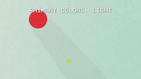
TVs make use of light’s colors to create the pictures we see. Each pixel of a TV screen contains some amount of red, green and blue light. The amount of each light determines the overall color of the pixel. So, each color on the TV comes from a combination of the primary colors of light: red, green and blue.

Space telescope images of celestial objects are also a combination of the colors of light.
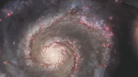
Every pixel that is collected can be broken down into its base colors. To learn even more, astronomers break the red, green and blue light down into even smaller sections called wavelengths.
This breakdown is called a spectrum.

With the right technology, every pixel of light can also be measured as a spectrum.

Images show us the big picture, while a spectrum reveals finer details. Astronomers use spectra to learn things like what molecules are in planet atmospheres and distant galaxies.
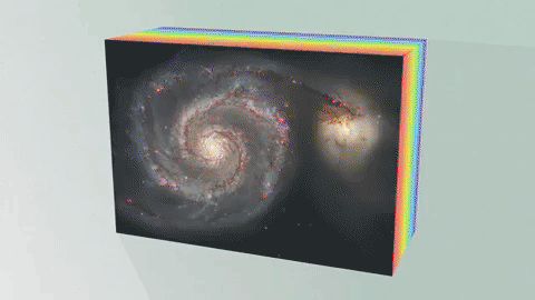
An Integral Field Unit, or IFU, is a special tool on the James Webb Space Telescope that captures images and spectra at the same time.
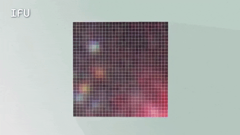
The IFU creates a unique spectrum for each pixel of the image the telescope is capturing, providing scientists with an enormous amount of valuable, detailed data. So, with an IFU we can get an image, many spectra and a better understanding of our universe.
Watch the full video where this method of learning about planetary atmospheres is explained:
The James Webb Space Telescope is our upcoming infrared space observatory, which will launch in 2021. It will spy the first galaxies that formed in the universe and shed light on how galaxies evolve, how stars and planetary systems are born and tell us about potentially habitable planets around other stars.
To learn more about NASA’s James Webb Space Telescope, visit the website, or follow the mission on Facebook, Twitter and Instagram.
Text and graphics credit: Space Telescope Science Institute
Make sure to follow us on Tumblr for your regular dose of space: http://nasa.tumblr.com.
Seven Reasons Why Rover Challenge is Serious Business
Prizes, awards and a year’s worth of bragging rights are at stake during our annual Human Exploration Rover Challenge. Year after year, student teams from across the world design, build and race rovers against the clock and each other.
With a space-themed obstacle course, unique rovers, competitive racing, our exhibits and dozens of international teams… it’s everything cool about STEM (science, technology, engineering and mathematics) and space exploration.
Here are the “must-know” details for this year’s event:
1. Bumps, Bruises and Battle Scars

Our space-themed obstacle course often brings racers to their knees, literally. This daunting three-quarter-mile long course is difficult to traverse and isn’t for the faint of heart. It uses both lunar and Mars-themed obstacles to simulate the types of terrain found on distant planets, asteroids or moons.
Plus, teams must race their rovers in, on and around full-scale rockets and space vehicle exhibits on display at the U.S. Space & Rocket Center – the official visitor center for NASA’s Marshall Space Flight Center, both in Huntsville, Alabama. See just how difficult and wild the course can be in our Flickr gallery.
2. Homemade Wheels Only

Rover teams must design and fabricate their own original, or “homemade” wheels. In-Situ Resource Utilization is an important component for our future missions to Mars, asteroids or other planets.
Astronauts can never simply purchase wheels at the store… and neither can our rover teams. Teams must not use any “off-the-shelf” wheels on their rover. By wheels, this means any component used for contact, traction or mobility on the surface of the obstacle course, including, but not limited to wheels, tracks, treads or belts.
And, as in years past, teams are not allowed to incorporate inflated (or un-inflated) pneumatic tires. Inflated tires would be considered an off-the-shelf product, not eligible under the current rules.
3. New “Sample Retrieval” Component Added

Teams may choose to compete in this optional challenge, collecting four samples (liquid, small pebbles, large rocks and soil) using a mechanical arm or a grabber they design and build. Teams must collect a soil sample and liquid sample while driving their rover, as well as collect rock samples (both large and small) while off the rover, all within a 25-minute time limit. The “Sample Retrieval” challenge highlights our deep-space exploration goals. Teams competing are eligible for the $250 prize awarded to the winner of each high school and college/university division.
4. Caution: Real STEM @work

The sights and sounds of welding, grinding and computer programming are prevalent in this hands-on, experiential activity where students solve similar problems faced by our workforce. Rover Challenge provides a unique test-bed to get students involved in real-world research and development. Their progress and success may glean potential technologies for future exploration of Mars and beyond.
5. Draws Inspiration from Apollo and Journey to Mars

Rover Challenge was inspired by the historic success of the lunar rovers from the Apollo missions, each one built by engineers and scientists at NASA Marshall. While we continue to honor our past achievements, we now highlight future accomplishments on deep-space exploration missions to Mars, asteroids or other planets. The addition of the “Sample Return” component and the Martian obstacles emphasize our commitment toward space exploration.
6. Our International Spirit is Alive and Well

Just like the International Space Station; we bring the best of several nations together to promote and celebrate space exploration. Nearly 80 teams are coming from as far away as Italy, Germany, India, Mexico, Columbia and Russia, as well as more “local” talent from the United States and Puerto Rico. View this year’s registered teams HERE.
7. Real-time Racing on Social Media

From start to finish, each racing rover team will be broadcast, live, on the Marshall Center’s Ustream channel. Plus, enjoy real-time race updates, results and awards by following Rover Challenge Twitter: @RoverChallenge
NASA’s Human Exploration Rover Challenge will take place at the U.S. Space & Rocket Center in Huntsville, Alabama, April 8-9. For event details, rules, course information and more, please visit: http://www.nasa.gov/roverchallenge
Make sure to follow us on Tumblr for your regular dose of space: http://nasa.tumblr.com
Innovation at 100
Air travel, spaceflight, robotic solar-system missions: science fiction to those alive at the turn of the 20th century became science fact to those living in the 21st.

America’s aerospace future has been literally made at our Langley Research Center by the best and brightest the country can offer. Here are some of the many highlights from a century of ingenuity and invention.
Making the Modern Airplane
In times of peace and war, Langley helped to create a better airplane, including unique wing shapes, sturdier structures, the first engine cowlings, and drag cleanup that enabled the Allies to win World War II.

In 1938 Langley mounted the navy's Brewster XF2A-1 Buffalo in the Full-Scale Tunnel for drag reduction studies.
Wind Goes to Work
Langley broke new ground in aeronautical research with a suite of first-of-their-kind wind tunnels that led to numerous advances in commercial, military and vertical flight, such as helicopters and other rotorcraft.

Airflow turning vanes in Langley’s 16-Foot Transonic Tunnel.
Aeronautics Breakthroughs
Aviation Hall of Famer Richard Whitcomb’s area rule made practical jet flight a reality and, thanks to his development of winglets and the supercritical wing, enabled jets to save fuel and fly more efficiently.

Richard Whitcomb examines a model aircraft incorporating his area rule.
Making Space
Langley researchers laid the foundation for the U.S. manned space program, played a critical role in the Mercury, Gemini and Apollo programs, and developed the lunar-orbit rendezvous concept that made the Moon landing possible.

Neil Armstrong trained for the historic Apollo 11 mission at the Lunar Landing Research Facility,
Safer Air Above and Below
Langley research into robust aircraft design and construction, runway safety grooving, wind shear, airspace management and lightning protection has aimed to minimize, even eliminate air-travel mishaps

NASA’s Boeing 737 as it approached a thunderstorm during microburst wind shear research in Colorado in 1992.
Tracking Earth from Aloft
Development by Langley of a variety of satellite-borne instrumentation has enabled real-time monitoring of planet-wide atmospheric chemistry, air quality, upper-atmosphere ozone concentrations, the effects of clouds and air-suspended particles on climate, and other conditions affecting Earth’s biosphere.

Crucial Shuttle Contributions
Among a number of vital contributions to the creation of the U.S. fleet of space shuttles, Langley developed preliminary shuttle designs and conducted 60,000 hours of wind tunnel tests to analyze aerodynamic forces affecting shuttle launch, flight and landing.

Space Shuttle model in the Langley wind tunnel.
Decidedly Digital
Helping aeronautics transition from analog to digital, Langley has worked on aircraft controls, glass cockpits, computer-aided synthetic vision and a variety of safety-enhancing onboard sensors to better monitor conditions while airborne and on the ground.

Aerospace research engineer Kyle Ellis uses computer-aided synthetic vision technology in a flight deck simulator.
Fast, Faster, Fastest
Langley continues to study ways to make higher-speed air travel a reality, from about twice the speed of sound – supersonic – to multiple times: hypersonic.

Langley continues to study ways to make higher-speed air travel a reality, from about twice the speed of sound – supersonic – to multiple times: hypersonic.
Safer Space Sojourns
Protecting astronauts from harm is the aim of Langley’s work on the Orion Launch Abort System, while its work on materials and structures for lightweight and affordable space transportation and habitation will keep future space travelers safe.

Unmasking the Red Planet
Beginning with its leadership role in Project Viking, Langley has helped to unmask Martian mysteries with a to-date involvement in seven Mars missions, with participation in more likely to come.

First image of Mars taken by Viking 1 Lander.
Touchdown Without Terror
Langley’s continued work on advanced entry, descent and landing systems aims to make touchdowns on future planetary missions routinely safe and secure.

Artist concept of NASA's Hypersonic Inflatable Aerodynamic Decelerator - an entry, descent and landing technology.
Going Green
Helping to create environmentally benign aeronautical technologies has been a focus of Langley research, including concepts to reduce drag, weight, fuel consumption, emissions, and lessen noise.

Intrepid Inventors
With a history developing next-generation composite structures and components, Langley innovators continue to garner awards for a variety of aerospace inventions with a wide array of terrestrial applications.

Boron Nitride Nanotubes: High performance, multi-use nanotube material.
Make sure to follow us on Tumblr for your regular dose of space: http://nasa.tumblr.com
How does it feel to into space for the first time? Like liftoff and leaving earth’s atmosphere? It seems like the world’s terrifying roller coaster, but what’s it really like?

Hurry! You Can Catch a Ride to Jupiter with NASA
Well, at least your name can.
One of the planet Jupiter’s largest and most intriguing moons is called Europa. Evidence hints that beneath its icy shell, Europa hides an ocean of liquid water – more water than all of Earth’s oceans combined. In 2024, our Europa Clipper robotic spacecraft sets sail to take a closer look…and when it launches, your name can physically be aboard! Here’s how:
NASA’s Message in a Bottle campaign invites people around the world to sign their names to a poem written by the U.S. Poet Laureate, Ada Limón. The poem connects the two water worlds — Earth, yearning to reach out and understand what makes a world habitable, and Europa, waiting with secrets yet to be explored.

The poem will be engraved on Europa Clipper, along with participants' names that will be physically etched onto microchips mounted on the spacecraft. Together, the poem and names will travel 1.8 billion miles to the Jupiter system.

Signing up is easy! Just go to this site to sign your name to the poem and get on board. You can send your name en español, too. Envía tu nombre aquí.
The Europa Clipper launch window opens in October 2024, but don’t wait – everyone’s names need to be received this year so they can be loaded onto the spacecraft in time. Sign up by Dec. 31, 2023.
We hope you’ll be riding along with us! Follow the mission at europa.nasa.gov.
Make sure to follow us on Tumblr for your regular dose of space!
-
 mega-mike-2-0 liked this · 9 months ago
 -
 invincibleworld liked this · 9 months ago
 -
 healing-thoughts-actions reblogged this · 1 year ago
 -
healing-thoughts-actions liked this · 1 year ago
-
 letuce369 reblogged this · 2 years ago
 -
 ceabeautii liked this · 2 years ago
 -
 the-void-in-general liked this · 3 years ago
 -
 appla1 reblogged this · 3 years ago
 -
 onemanonegod liked this · 3 years ago
 -
 youthhopes reblogged this · 3 years ago
 -
 notsospoon liked this · 3 years ago
 -
 somni-omni liked this · 3 years ago
 -
 spaceinvaderhere reblogged this · 3 years ago
 -
 saltythexfilesindianjonescop liked this · 3 years ago
 -
 technologistsinsync reblogged this · 3 years ago
 -
 sagacious-sam liked this · 3 years ago
 -
 raventhinks reblogged this · 3 years ago
 -
 level-666 liked this · 3 years ago
 -
 jdsme liked this · 3 years ago
 -
 wuvupandesal liked this · 3 years ago
 -
 da-mage liked this · 3 years ago
 -
 jaclynwashere reblogged this · 3 years ago
 -
 izmarvelous liked this · 3 years ago
 -
 shirodumbclownwolf liked this · 3 years ago
 -
 ahmed-mer-blog liked this · 3 years ago
 -
 pinkiepieaddict reblogged this · 3 years ago
 -
 biblioimmortal reblogged this · 3 years ago
 -
 algorizmi reblogged this · 3 years ago
 -
 tools333 liked this · 3 years ago
Explore the universe and discover our home planet with the official NASA Tumblr account
1K posts