Clouds Swirling In The Coffee Colored Atmosphere Of Jupiter, Looks More Like A Familiar Morning Beverage

Clouds swirling in the coffee colored atmosphere of Jupiter, looks more like a familiar morning beverage of champions.
This image from our Juno spacecraft was captured in North North Temperate Belt. Image Credit: Enhanced Image by Gerald Eichstädt and Sean Doran (CC BY-NC-SA)/NASA/JPL-Caltech/SwRI/MSSS
Make sure to follow us on Tumblr for your regular dose of space: http://nasa.tumblr.com
More Posts from Nasa and Others
What advice do you have for Hispanic boys and girls who see themselves in you and are inspired by your achievements?
Our Spacecraft Have Discovered a New Magnetic Process in Space
Just as gravity is one key to how things move on Earth, a process called magnetic reconnection is key to how electrically-charged particles speed through space. Now, our Magnetospheric Multiscale mission, or MMS, has discovered magnetic reconnection – a process by which magnetic field lines explosively reconfigure – occurring in a new and surprising way near Earth.

Invisible to the eye, a vast network of magnetic energy and particles surround our planet — a dynamic system that influences our satellites and technology. The more we understand the way those particles move, the more we can protect our spacecraft and astronauts both near Earth and as we explore deeper into the solar system.

Earth’s magnetic field creates a protective bubble that shields us from highly energetic particles that stream in both from the Sun and interstellar space. As this solar wind bathes our planet, Earth’s magnetic field lines get stretched. Like elastic bands, they eventually release energy by snapping and flinging particles in their path to supersonic speeds.

That burst of energy is generated by magnetic reconnection. It’s pervasive throughout the universe — it happens on the Sun, in the space near Earth and even near black holes.

Scientists have observed this phenomenon many times in Earth’s vast magnetic environment, the magnetosphere. Now, a new study of data from our MMS mission caught the process occurring in a new and unexpected region of near-Earth space. For the first time, magnetic reconnection was seen in the magnetosheath — the boundary between our magnetosphere and the solar wind that flows throughout the solar system and one of the most turbulent regions in near-Earth space.

The four identical MMS spacecraft — flying through this region in a tight pyramid formation — saw the event in 3D. The arrows in the data visualization below show the hundreds of observations MMS took to measure the changes in particle motion and the magnetic field.

The data show that this event is unlike the magnetic reconnection we’ve observed before. If we think of these magnetic field lines as elastic bands, the ones in this region are much smaller and stretchier than elsewhere in near-Earth space — meaning that this process accelerates particles 40 times faster than typical magnetic reconnection near Earth. In short, MMS spotted a completely new magnetic process that is much faster than what we’ve seen before.

What’s more, this observation holds clues to what’s happening at smaller spatial scales, where turbulence takes over the process of mixing and accelerating particles. Turbulence in space moves in random ways and creates vortices, much like when you mix milk into coffee. The process by which turbulence energizes particles in space is still a big area of research, and linking this new discovery to turbulence research may give insights into how magnetic energy powers particle jets in space.
Keep up with the latest discoveries from the MMS mission: @NASASun on Twitter and Facebook.com/NASASunScience.
Make sure to follow us on Tumblr for your regular dose of space: http://nasa.tumblr.com.
5 Examples of How Our Satellite Data is Helping the Planet
We could talk all day about how our satellite data is crucial for Earth science…tracking ocean currents, monitoring natural disasters, soil mapping – the list goes on and on.
But did you know there is another way this data can improve life here on Earth?

Our satellite data can be used to build businesses and commercial products – but finding and using this data has been a daunting task for many potential users because it’s been stored across dozens of websites.
Until now.
Our Technology Transfer program has just released their solution to make finding data easier, called The NASA Remote Sensing Toolkit (RST).

RST offers an all-in-one approach to finding and using our Earth Science data, the tools needed to analyze it, and software to build your own tools.
Before, we had our petabytes on petabytes of information spread out across dozens of websites – not to mention the various software tools needed to interpret the data.

Now, RST helps users find everything they need while having only one browser open.
Feeling inspired to innovate with our data? Here are just a few examples of how other companies have taken satellite data and turned it into products, known as NASA spinoffs, that are helping our planet today.
1. Bringing Landscape into Focus

We have a number of imaging systems for locating fires, but none were capable of identifying small fires or indicating the flames’ intensity. Thanks to a series of Small Business Innovation Research (SBIR) contracts between our Ames Research Center and Xiomas Technologies LLC, the Wide Area Imager aerial scanner does just that. While we and the U.S. Forest Service use it for fire detection, the tool is also being used by municipalities for detailed aerial surveillance projects.
2. Monitoring the Nation’s Forests with the Help of Our Satellites

Have you ever thought about the long-term effects of natural disasters, such as hurricanes, on forest life? How about the big-time damage caused by little pests, like webworms?
Our Stennis Space Center did, along with multiple forest services and environmental threat assessment centers. They partnered to create an early warning system to identify, characterize, and track disturbances from potential forest threats using our satellite data. The result was ForWarn, which is now being used by federal and state forest and natural resource managers.
3. Informing Forecasts of Crop Growth

Want to hear a corny story?
Every year Stennis teams up with the U.S. Department of Agriculture to host a program called Ag 20/20 to utilize remote sensing technology for operational use in agricultural crop management practices at the level of individual farms. During Ag 20/20 in 2000, an engineering contractor developed models for using our satellite data to predict corn crop yield. The model was eventually sold to Genscape Inc., which has commercialized it as LandViewer. Sold under a subscription model, LandViewer software provides predictions of corn production to ethanol plants and grain traders.
4. Water Mapping Technology Rebuilds Lives in Arid Regions

No joking around here. Lives depend on the ability to find precious water in areas with little of it.
Using our Landsat satellite and other topographical data, Radar Technologies International developed an algorithm-based software program that can locate underground water sources. Working with international organizations and governments, the firm is helping to provide water for refugees and other people in drought-stricken regions such as Kenya, Sudan, and Afghanistan.
5. Satellite Maps Deliver More Realistic Gaming

Are you more of the creative type? This last entry used satellite data to help people really get into their gameplay.
When Electronic Arts (EA) decided to make SSX, a snowboarding video game, it faced challenges in creating realistic-looking mountains. The solution was our ASTER Global Digital Elevation Map, made available by our Jet Propulsion Laboratory, which EA used to create 28 real-life mountains from 9 different ranges for its award-winning game.
You can browse our Remote Sensing Toolkit at technology.nasa.gov.
Want to know more about future tutorial webinars on RST?
Follow our Technology Transfer Program on twitter @NASAsolutions for the latest updates.
Want to learn more about the products made by NASA technologies? Head over to spinoff.nasa.gov.
Sign up to receive updates about upcoming tutorials HERE.
Make sure to follow us on Tumblr for your regular dose of space: http://nasa.tumblr.com.
What’s Inside a ‘Dead’ Star?
Matter makes up all the stuff we can see in the universe, from pencils to people to planets. But there’s still a lot we don’t understand about it! For example: How does matter work when it’s about to become a black hole? We can’t learn anything about matter after it becomes a black hole, because it’s hidden behind the event horizon, the point of no return. So we turn to something we can study – the incredibly dense matter inside a neutron star, the leftover of an exploded massive star that wasn’t quite big enough to turn into a black hole.

Our Neutron star Interior Composition Explorer, or NICER, is an X-ray telescope perched on the International Space Station. NICER was designed to study and measure the sizes and masses of neutron stars to help us learn more about what might be going on in their mysterious cores.

When a star many times the mass of our Sun runs out of fuel, it collapses under its own weight and then bursts into a supernova. What’s left behind depends on the star’s initial mass. Heavier stars (around 25 times the Sun’s mass or more) leave behind black holes. Lighter ones (between about eight and 25 times the Sun’s mass) leave behind neutron stars.

Neutron stars pack more mass than the Sun into a sphere about as wide as New York City’s Manhattan Island is long. Just one teaspoon of neutron star matter would weigh as much as Mount Everest, the highest mountain on Earth!

These objects have a lot of cool physics going on. They can spin faster than blender blades, and they have powerful magnetic fields. In fact, neutron stars are the strongest magnets in the universe! The magnetic fields can rip particles off the star’s surface and then smack them down on another part of the star. The constant bombardment creates hot spots at the magnetic poles. When the star rotates, the hot spots swing in and out of our view like the beams of a lighthouse.

Neutron stars are so dense that they warp nearby space-time, like a bowling ball resting on a trampoline. The warping effect is so strong that it can redirect light from the star’s far side into our view. This has the odd effect of making the star look bigger than it really is!

NICER uses all the cool physics happening on and around neutron stars to learn more about what’s happening inside the star, where matter lingers on the threshold of becoming a black hole. (We should mention that NICER also studies black holes!)

Scientists think neutron stars are layered a bit like a golf ball. At the surface, there’s a really thin (just a couple centimeters high) atmosphere of hydrogen or helium. In the outer core, atoms have broken down into their building blocks – protons, neutrons, and electrons – and the immense pressure has squished most of the protons and electrons together to form a sea of mostly neutrons.
But what’s going on in the inner core? Physicists have lots of theories. In some traditional models, scientists suggested the stars were neutrons all the way down. Others proposed that neutrons break down into their own building blocks, called quarks. And then some suggest that those quarks could recombine to form new types of particles that aren’t neutrons!

NICER is helping us figure things out by measuring the sizes and masses of neutron stars. Scientists use those numbers to calculate the stars’ density, which tells us how squeezable matter is!
Let’s say you have what scientists think of as a typical neutron star, one weighing about 1.4 times the Sun’s mass. If you measure the size of the star, and it’s big, then that might mean it contains more whole neutrons. If instead it’s small, then that might mean the neutrons have broken down into quarks. The tinier pieces can be packed together more tightly.

NICER has now measured the sizes of two neutron stars, called PSR J0030+0451 and PSR J0740+6620, or J0030 and J0740 for short.
J0030 is about 1.4 times the Sun’s mass and 16 miles across. (It also taught us that neutron star hot spots might not always be where we thought.) J0740 is about 2.1 times the Sun’s mass and is also about 16 miles across. So J0740 has about 50% more mass than J0030 but is about the same size! Which tells us that the matter in neutron stars is less squeezable than some scientists predicted. (Remember, some physicists suggest that the added mass would crush all the neutrons and make a smaller star.) And J0740’s mass and size together challenge models where the star is neutrons all the way down.

So what’s in the heart of a neutron star? We’re still not sure. Scientists will have to use NICER’s observations to develop new models, perhaps where the cores of neutron stars contain a mix of both neutrons and weirder matter, like quarks. We’ll have to keep measuring neutron stars to learn more!
Keep up with other exciting announcements about our universe by following NASA Universe on Twitter and Facebook.
Make sure to follow us on Tumblr for your regular dose of space: http://nasa.tumblr.com.
A Tour of our Moon
Want to go to the Moon?
Let our Lunar Reconnaissance Orbiter take you there!

Our lunar orbiter, also known as LRO, has been collecting data on lunar topography, temperature, resources, solar radiation, and geology since it launched nine years ago. Our latest collection of this data is now in 4K resolution. This updated "Tour of the Moon" takes you on a virtual tour of our nearest neighbor in space, with new science updates from the vastly expanded data trove.
Orientale Basin

First stop, Orientale Basin located on the rim of the western nearside. It's about the size of Texas and is the best-preserved impact structure on the Moon. Topography data from LRO combined with gravity measurements from our twin GRAIL spacecraft reveal the structure below the surface and help us understand the geologic consequences of large impacts.
South-Pole and Shackleton Crater

Unlike Earth, the Moon's axis is barely tilted relative to the Sun. This means that there are craters at the poles where the sunlight never reaches, called permanently shadowed regions. As a result, the Moon's South Pole has some of the coldest measured places in the solar system. How cold? -410 degrees F.
Because these craters are so cold and dark, water that happens to find its way into them never has the opportunity to evaporate. Several of the instruments on LRO have found evidence of water ice, which you can see in the highlighted spots in this visualization.
South-Pole Aitken Basin

South Pole-Aitken Basin is the Moon's largest, deepest and oldest observed impact structure. Its diameter is about 2,200 km or 1,367 miles across and takes up 1/4 of the Moon! If there was a flat, straight road and you were driving 60 mph, it would take you about 22 hours to drive across. And the basin is so deep that nearly two Mount Everests stacked on each other would fit from the bottom of the basin to the rim. South-Pole Aitken Basin is a top choice for a landing site on the far side of the Moon.
Tycho Crater

Now let's go to the near side. Tycho Crater is 100 million years young. Yes, that's young in geologic time. The central peak of the impact crater likely formed from material that rebounded back up after being compressed in the impact, almost like a spring. Check out that boulder on top. It looks small in this image, but it could fill a baseball stadium.
Aristarchus Plateau

Also prominent on the nearside is the Aristarchus Plateau. It features a crater so bright that you could see it with your naked eye from Earth! The Aristarchus Plateau is particularly interesting to our scientists because it reveals much of the Moon's volcanic history. The region is covered in rocks from volcanic eruptions and the large river-like structure is actually a channel made from a long-ago lava flow.
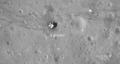
Apollo 17 Landing Site
As much as we study the Moon looking for sites to visit, we also look back at places we've already been. This is because the new data that LRO is gathering helps us reinterpret the geology of familiar places, giving scientists a better understanding of the sequence of events in early lunar history.
Here, we descend to the Apollo 17 landing site in the Taurus-Littrow valley, which is deeper than the Grand Canyon. The LRO camera is even able to capture a view of the bottom half of the Apollo 17 Lunar Lander, which still sits on the surface, as well as the rover vehicle. These images help preserve our accomplishment of human exploration on the Moon's surface.
North Pole

Finally, we reach the North Pole. Like the South Pole, there are areas that are in permanent shadow and others that bask in nearly perpetual light. LRO scientists have taken detailed brightness and terrain measurements of the North Pole in order to model these areas of sunlight and shadow through time. Sunlit peaks and crater rims here may be ideal locations for generating solar power for future expeditions to the Moon.
LRO was designed as a one-year mission. Now in its ninth year, the spacecraft and the data emphasize the power of long-term data collection. Thanks to its many orbits around the Moon, we have been able to expand on lunar science from the Apollo missions while paving the way for future lunar exploration. And as the mission continues to gather data, it will provide us with many more opportunities to take a tour of our Moon.
And HERE's the full “Tour of the Moon” video:
We hope you enjoyed the tour. If you'd like to explore the moon further, please visit moon.nasa.gov and moontrek.jpl.nasa.gov.
Make sure to follow @NASAMoon on Twitter for the latest lunar updates and photos.
Make sure to follow us on Tumblr for your regular dose of space: http://nasa.tumblr.com
When you first saw Earth from all the way up in space, what were your first thoughts? Did it change the way you viewed things?
Want to Become an Astronaut? You Might Be More Qualified Than You Think
Have you ever wondered if you have what it takes to become a NASA Astronaut? We’re accepting applications starting March 2, and we’re encouraging all eligible Americans to apply by March 31!
It’s an incredible time in human spaceflight to be an astronaut. With Artemis, our sights are set on the Moon – to stay – by utilizing sustainable lunar missions, and you could be one of the humans on the surface! During their careers, this next class of astronauts may also fly on any of four different U.S. spacecraft: the International Space Station, Boeing’s CST-100 Starliner, SpaceX’s Crew Dragon and our Orion deep-space exploration vehicle; They will be at the cutting edge of a new era in human exploration.
So, still interesting in joining our ranks as an Artemis generation astronaut? Here are a few things to note.
Myths about becoming an astronaut:

MYTH: All astronauts have piloting experience.
FACT: You don’t need to be a pilot to be an astronaut. Flying experience is not a requirement, but could be beneficial to have.

MYTH: All astronauts have perfect vision.
FACT: It’s okay if you don’t have 20/20 vision. As of September 2007, corrective surgical procedures of the eye (PRK and LASIK), are now allowed, providing at least 1 year has passed since the date of the procedure with no permanent adverse after effects.

MYTH: All astronauts have advanced degrees like, a PhD.
FACT: While a Master’s degree from an accredited university is necessary, the requirement can also be met with the completion (or current enrollment that will result in completion by June 2021) of a nationally recognized test pilot school program.

MYTH: Astronauts are required to have military experience in order to be selected.
FACT: Military experience is not required to become an astronaut.

MYTH: You have to be a certain age in order to be an astronaut.
FACT: There are no age restrictions. Astronaut candidates selected in the past have ranged between the ages of 26 and 46, with the average age being 34.
Okay, but what are the requirements?

The basic requirements to apply include United States citizenship and a master’s degree in a STEM field, including engineering, biological science, physical science, computer science, or mathematics, from an accredited institution. The requirement for the master’s degree can also be met by:
Two years (36 semester hours or 54 quarter hours) of work toward a Ph.D. program in a related science, technology, engineering or math field;
A completed doctor of medicine or doctor of osteopathic medicine degree;
Completion (or current enrollment that will result in completion by June 2021) of a nationally recognized test pilot school program.
Candidates also must have at least two years of related, progressively responsible professional experience, or at least 1,000 hours of pilot-in-command time in jet aircraft. Astronaut candidates must pass the NASA long-duration spaceflight physical.

Applications for our next Artemis astronaut class open on March 2! Shoot for the stars and visit: https://www.nasa.gov/astronauts
Make sure to follow us on Tumblr for your regular dose of space: http://nasa.tumblr.com
View these celestial beauties taken by the Hubble Space Telescope and released as a set of views in a modern day "Messier Catalog."
Spotting comets was all the rage in the middle of the 18th century, and at the forefront of the comet hunt was a young French astronomer named Charles Messier. In 1774, in an effort to help fellow comet seekers steer clear of astronomical objects that were not comets (something that frustrated his own search for these elusive entities), Messier published the first version of his “Catalog of Nebulae and Star Clusters,” a collection of celestial objects that weren’t comets and should be avoided during comet hunting. Today, rather than avoiding these objects, many amateur astronomers actively seek them out as interesting targets to observe with backyard telescopes, binoculars or sometimes even with the naked eye.
Hubble’s version of the Messier catalog includes eight newly processed images never before released by NASA. The images were extracted from more than 1.3 million observations that now reside in the Hubble data archive. Some of these images represent the first Hubble views of the objects, while others include newer, higher resolution images taken with Hubble’s latest cameras.
Learn more: https://www.nasa.gov/content/goddard/hubble-s-messier-catalog
Make sure to follow us on Tumblr for your regular dose of space: http://nasa.tumblr.com.
5 NASA Software Codes You Can Download – For Free!
One of the biggest steps of any mission starts right here on Earth at a computer desk – NASA runs on software, period. Rovers can’t move, spacecraft can’t fly, even rockets can’t blast off without the software codes that run them all.
We’ve compiled hundreds of these powerful codes into one location at software.nasa.gov. And guess what? You can start downloading them right now for free! Here are just a few you can use:
1. TetrUSS (Tetrahedral Unstructured Software System)
TetrUSS has been used extensively for space launch vehicle analysis and design, like on the Space Launch System, which is planned to take humans to Mars.

You really could say it's helping us to “blast off.” Outside of NASA, this software has been used to analyze Mars planetary entry vehicles, ballistics and even high-altitude sky diver aerodynamics. Basically if anything has moved through any planetary atmosphere, this software has played a role.
2. KNIFE (part of the FUN3D software and released as a package)
The name may be a bit intimidating, but with good reason – KNIFE packs a powerful punch.

It was created to help us learn more about the sonic booms that resonate when planes break the sound barrier, but it has also helped develop green energy sources such as wind turbines and techniques to minimize drag for long-haul trucking. Maybe we should re-name this versatile and handy code, “Swiss Army KNIFE?”
3. Cart3D (Automated Triangle Geometry Processing for Surface Modeling and Cartesian Grid Generation)
If software codes went to high school, Cart3D would be Prom Queen. This software is so popular, it is being used in almost every mission area here at NASA.

Engineers and scientists are currently using it to model everything from advanced drones to quieter supersonic aircraft.
4. FACET (Future Air Traffic Management Concepts Evaluation Tool)
Frequent flyers: this may be your favorite code without even knowing it. FACET was developed to evaluate futuristic concepts in air traffic management, and it has served as a testbed for assessing today’s regular operations.

To sum it up, this software code helps airports keep planes organized in the air and on the ground.
5. GIPSY-OASIS
GIPSY-OASIS is part of the GPS system to end all GPS systems. It’s so accurate, John Deere used it to help create self-driving tractors.

How? John Deere already had a navigation system in the works, but it could only be used in certain parts of the world.

Our ground stations are all across the globe, and our software ensures accuracy down to a few inches. And so, a new breed of tractor was born! Did we mention this software is free?
These are just a few examples of the software NASA has available for free public and consumer use. To browse the catalog online, check out software.nasa.gov.
Make sure to follow us on Tumblr for your regular dose of space: http://nasa.tumblr.com
Is there a pot of gold at the end of a green aurora? Not sure, but these dancing green lights provide a spectacular view fitting for the St. Patrick’s Day holiday.
This stunning aurora was captured by NASA astronaut Jeff Williams during his 2016 mission on the International Space Station.
Even though auroras are best seen at night, they are actually caused by the sun. The sun sends us more than just heat a light…it sends lots of other energy and small particles toward Earth. The protective magnetic field around Earth shields us from most of the energy and particles. Sometimes, the particles interact with gases in our atmosphere resulting in beautiful displays of light in the sky. Oxygen gives off green and red light, while nitrogen glows blue and purple.
Happy St. Patrick’s Day!
Make sure to follow us on Tumblr for your regular dose of space: http://nasa.tumblr.com
-
 lavend-err reblogged this · 1 month ago
 -
 space-cat010 liked this · 3 months ago
 -
 windslime liked this · 9 months ago
 -
 nutsamodebadze liked this · 1 year ago
 -
 saucerkommand liked this · 1 year ago
 -
 dailymusemaniac reblogged this · 1 year ago
 -
 cryptkasper liked this · 1 year ago
 -
 kaisaccofilm liked this · 1 year ago
 -
 0815-4711-02 liked this · 2 years ago
 -
 fakevince liked this · 2 years ago
 -
 bnoface liked this · 3 years ago
 -
 captain-puffin liked this · 3 years ago
 -
 non-static reblogged this · 3 years ago
 -
 multiple-identities-1134 reblogged this · 3 years ago
 -
 mybrainisalibrary liked this · 3 years ago
 -
 the-gotheltic-rowan reblogged this · 3 years ago
 -
 a-republican-mind reblogged this · 3 years ago
Explore the universe and discover our home planet with the official NASA Tumblr account
1K posts