This Week @ NASA--April 14, 2017
This Week @ NASA--April 14, 2017
Cassini and the Hubble Space Telescope, two of our long-running missions, are providing new details about the ocean-bearing moons of Jupiter and Saturn. Hubble's monitoring of plume activity on Europa and Cassini's long-term investigation of Enceladus are laying the groundwork for our Europa Clipper mission, slated for launch in the 2020s. Also, Shane Kimbrough returns home after 171 days aboard the Space Station, celebrating the first Space Shuttle mission and more!

Ocean Worlds
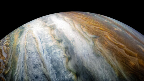
Our two long-running missions, Cassini and the Hubble Space Telescope, are providing new details about “ocean worlds,” specifically the moons of Jupiter and Saturn.

The details – discussed during our April 13 science briefing – included the announcement by the Cassini mission team that a key ingredient for life has been found in the ocean on Saturn's moon Enceladus.

Meanwhile, in 2016 Hubble spotted a likely plume erupting from Jupiter’s moon Europa at the same location as one in 2014, reenforcing the notion of liquid water erupting from the moon.

These observations are laying the groundwork for our Europa Clipper mission, planned for launch in the 2020s.

Welcome Home, Shane!
Shane Kimbrough and his Russian colleagues returned home safely after spending 173 days in space during his mission to the International Space Station.

Meet the Next Crew to Launch to the Station
Meanwhile, astronaut Peggy Whitson assumed command of the orbital platform and she and her crew await the next occupants of the station, which is slated to launch April 20.

Student Launch Initiative
We’ve announced the preliminary winner of the 2017 Student Launch Initiative that took place near our Marshall Space Fight Center, The final selection will be announced in May. The students showcased advanced aerospace and engineering skills by launching their respective model rockets to an altitude of one mile, deploying an automated parachute and safely landing them for re-use.

Langley’s New Lab
On April 11, a ground-breaking ceremony took place at our Langley Research Center for the new Systems Measurement Laboratory. The 175,000 square-foot facility will be a world class lab for the research and development of new measurement concepts, technologies and systems that will enable the to meet its missions in space explorations, science and aeronautics.

Yuri’s Night
Space fans celebrated Yuri’s Night on April 12 at the Air and Space Museum and around the world. On April 12, 1961, cosmonaut Yuri Gagrin became the first person to orbit the Earth.

Celebrating the First Space Shuttle Launch
On April 12, 1981, John Young and Bob Crippin launched aboard Space Shuttle Columbia on STS-1 a two-day mission, the first of the Shuttle Program’s 30-year history.

Watch the full episode:
Make sure to follow us on Tumblr for your regular dose of space: http://nasa.tumblr.com
More Posts from Nasa and Others
Behold—the space station of the future! (…from 1973)

This artist’s concept gives a cutaway view of the Skylab orbital workshop, which launched 50 years ago on May 14, 1973. Established in 1970, the Skylab Program's goals were to enrich our scientific knowledge of Earth, the sun, the stars, and cosmic space; to study the effects of weightlessness on living organisms; to study the effects of the processing and manufacturing of materials in the absence of gravity; and to conduct Earth-resource observations.
Three crews visited Skylab and carried out 270 scientific and technical investigations in the fields of physics, astronomy, and biological sciences. They also proved that humans could live and work in outer space for extended periods of time, laying the groundwork for the International Space Station.
Make sure to follow us on Tumblr for your regular dose of space!
Falling Into Jupiter
Twenty-five years ago, an object roughly the size of an oven made space history when it plunged into the clouds of Jupiter, the largest planet in our solar system. On Dec. 7, 1995, the 750-pound Galileo probe became the first probe to enter the gas giant. Traveling at a blistering speed of 106,000 miles per hour, the probe’s protective heat shield experienced temperatures as hot as the Sun’s surface generated by friction during entry. As the probe parachuted through Jupiter’s dense atmosphere, its science instruments made measurements of the planet’s chemical and physical makeup. The probe collected data for nearly an hour before its signal was lost. Its data was transmitted to Earth via the Galileo spacecraft, an orbiter that carried the probe to Jupiter and stayed within contact during the encounter. Learn more about the mission.
The Galileo probe was launched to space aboard space shuttle Atlantis in 1989

The probe consisted of a descent module and a protective deceleration module

The probe traveled to Jupiter attached to the Galileo spacecraft

The probe was released from the spacecraft in July 1995

The probe entered Jupiter’s atmosphere five months later on Dec. 7, 1995

Parachutes were deployed to slow the probe’s descent

The probe collected science data for 58 minutes as it fell into the planet’s atmosphere

The Galileo probe was managed by NASA’s Ames Research Center in California’s Silicon Valley.
Make sure to follow us on Tumblr for your regular dose of space: http://nasa.tumblr.com
What’s Up for July 2017
Prepare for the August total solar eclipse by observing the moon phases this month. Plus, two meteor showers peak at the end of July.

Solar eclipses occur when the new moon passes between the Earth and the sun and moon casts a traveling shadow on Earth. A total solar eclipse occurs when the new moon is in just the right position to completely cover the sun’s disk.

This will happen next month on August 21, when the new month completely blocks our view of the sun along a narrow path from Oregon to South Carolina.

It may even be dark enough during the eclipse to see some of the brighter stars and few planets!

Two weeks before or after a solar eclipse, there is often, but not always, a lunar eclipse. This happens because the full moon, the Earth and the sun will be lined up with Earth in the middle.

Beginning July 1, we can see all the moon’s phases.

Many of the Apollo landing sites are on the lit side of the first quarter moon. But to see these sites, you’ll have to rely on images for lunar orbiting spacecraft.

On July 9, the full moon rises at sunset and July 16 is the last quarter. The new moon begins on July 23 and is the phase we’ll look forward to in August, when it will give us the total solar eclipse. The month of July ends with a first quarter moon.

We’ll also have two meteor showers, both of which peak on July 30. The Delta Aquarids will have 25 meteors per hour between midnight and dawn.

The nearby slow and bright Alpha Capricornids per at 5 per hour and often produce fireballs.
Watch the full video:
Make sure to follow us on Tumblr for your regular dose of space: http://nasa.tumblr.com

NASA Spotlight: Brandon Rodriguez, Jet Propulsion Laboratory Education Specialist
Brandon Rodriguez is an education specialist at our Jet Propulsion Laboratory (JPL) in Pasadena, California where he provides resources and training to K-12 schools across the Southwest. Working with a team at JPL, he develops content for classroom teachers, visits schools and speaks with students and trains future teachers to bring NASA into their classroom. When he’s not in the classroom, Brandon’s job takes him on research expeditions all around the world, studying our planet’s extreme environments.
Fun fact: Brandon wakes up every morning to teach an 8 a.m. physics class at a charter school before heading to JPL and clocking in at his full time job. When asked why? He shared, “The truth is that I really feel so much better about my role knowing that we’re not ‘telling’ teachers what to do from our ivory tower. Instead, I can “share” with teachers what I know works not just in theory, but because I’m still there in the classroom doing it myself.” - Brandon Rodriguez
Brandon took time from exciting the next generation of explorers to answer some questions about his life and his career:
What inspired you to work in the educational department at NASA?
I was over the moon when I got a call from NASA Education. I began my career as a research scientist, doing alternative energy work as a chemist. After seven years in the field, I began to feel as if I had a moral responsibility to bring access to science to a the next generation. To do so, I quit my job in science and became a high school science teacher. When NASA called, they asked me if I wanted a way to be both a scientist and an educator- how could I resist?

You were born in Venezuela and came to the U.S. when you were 12 years old. Can you tell us the story of why and how you came to America?
I haven't been back to Venezuela since I was very young, which has been very difficult for me. Being an immigrant in the USA sometimes feels like you're an outsider of both sides: I'm not truly Latin, nor am I an American. When I was young, I struggled with this in ways I couldn't articulate, which manifested in a lot of anger and got me in quite a bit of trouble. Coming to California and working in schools that are not only primarily Latinx students, but also first generation Latinx has really helped me process that feeling, because it's something I can share with those kids. What was once an alienating force has become a very effective tool for my teaching practice.
Does your job take you on any adventures outside of the classroom and if so, what have been your favorite endeavors?
I'm so fortunate that my role takes me all over the world and into environments that allow to me to continue to develop while still sharing my strengths with the education community. I visit schools all over California and the Southwest of the USA to bring professional development to teachers passionate about science. But this year, I was also able to join the Ocean Exploration Trust aboard the EV Nautilus as we explored the Pacific Remote Island National Marine Monument. We were at sea for 23 days, sailing from American Samoa to Hawaii, using submersible remotely operated vehicles to explore the ocean floor.

Image Credit: Nautilus Live
We collected coral and rock samples from places no one has ever explored before, and observed some amazing species of marine creatures along the way.

Image Credit: Nautilus Live
What keeps you motivated to go to work every day?
There's no greater motivation than seeing the product of your hard work, and I get that everyday through students. I get to bring them NASA research that is "hot off the press" in ways that their textbooks never can. They see pictures not online or on worksheets, but from earlier that day as I walked through JPL. It is clearly that much more real and tangible to them when they can access it through their teacher and their community.

Do you have any tips for people struggling with their science and math classes?
As someone who struggled- especially in college- I want people to know that what they struggle with isn't science, it's science classes. The world of research doesn't have exams; it doesn't have blanks to be filled in or facts to be memorized. Science is exploring the unknown. Yes, of course we need the tools to properly explore, and that usually means building a strong academic foundation. But it helped me to differentiate the end goal from the process: I was bad at science tests, but I wanted to someday be very good at science. I could persevere through the former if it got me to the latter.
If you could safely visit any planet, star, or solar system, where would you visit and what would you want to learn?
Europa, without a doubt. Imagine if we found even simple life once more in our solar system- and outside of the habitable zone, no less. What would this mean for finding life outside of our solar system as a result? We would surely need to conclude that our sky is filled with alien worlds looking back at us.

Is there a moment or project that you feel defined (or significantly impacted) your career up to today?
While I never worked closely with the mission, Insight was a really important project for me. It's the first time while at JPL I was able to see the construction, launch and landing of a mission.
If you could name a spaceship, what would you name it?
For as long as I can remember, I've been watching and reading science fiction, and I continue to be amazed at how fiction informs reality. How long ago was it that in Star Trek, the crew would be handing around these futuristic computer tablets that decades later would become common iPads? In their honor, I would be delighted if we named a ship Enterprise.
Thanks so much Brandon!
Additional Image Credit: MLParker Media
Make sure to follow us on Tumblr for your regular dose of space: http://nasa.tumblr.com
Isolation, Hazard of the Mind
Make sure to follow us on Tumblr for your regular dose of space: http://nasa.tumblr.com.A human journey to Mars, at first glance, offers an inexhaustible amount of complexities. To bring a mission to the Red Planet from fiction to fact, our Human Research Program has organized hazards astronauts will encounter on a continual basis into five classifications. (View the first hazard). Let’s dive into the second hazard:

Overcoming the second hazard, isolation and confinement, is essential for a successful mission to Mars. Behavioral issues among groups of people crammed in a small space over a long period of time, no matter how well trained they are, are inevitable. It is a topic of study and discussion currently taking place around the selection and composition of crews.

On Earth, we have the luxury of picking up our cell phones and instantly being connected with nearly everything and everyone around us.

On a trip to Mars, astronauts will be more isolated and confined than we can imagine.

Sleep loss, circadian desynchronization (getting out of sync), and work overload compound this issue and may lead to performance decrements or decline, adverse health outcomes, and compromised mission objectives.

To address this hazard, methods for monitoring behavioral health and adapting/refining various tools and technologies for use in the spaceflight environment are being developed to detect and treat early risk factors. Research is also being conducted in workload and performance, light therapy for circadian alignment or internal clock alignment, and team cohesion.

Exploration to the Moon and Mars will expose astronauts to five known hazards of spaceflight, including isolation and confinement. To learn more, and find out what the Human Research Program is doing to protect humans in space, check out the "Hazards of Human Spaceflight" website. Or, check out this week’s episode of “Houston We Have a Podcast,” in which host Gary Jordan further dives into the threat of isolation and confinement with Tom Williams, a NASA Human Factors and Behavior Performance Element Scientist at the Johnson Space Center.

Make sure to follow us on Tumblr for your regular dose of space: http://nasa.tumblr.com.
Anonymous asked:
What is the best about being mission control?
Solar System: Things To Know This Week
Weather permitting, you can observe the Moon most nights, unless it's a new moon, when the lighted side of the Moon faces away from Earth. The Moon is by far the brightest object in the night sky and there's plenty to see. But this week is special...

...October 28 is International Observe the Moon Night (also known as InOMN).
Here's all you need to know to join in and celebrate:
1. One Planet. One Moon. One Night.

Everyone on Earth is invited to join the celebration by hosting or attending an InOMN event and uniting on one day each year to look at and learn about the Moon together.
2. What's Up?

October's night skies are full of sights, from the first quarter Moon on InOMN to Saturn making a cameo appearance above the Moon October 23 and 24. Watch our What's Up video for details.
3. Be Social

Hundreds of events are planned around the globe. Click the top link on this page for a handy map. You can also register your own event.
4. Don't Just Stand There

Here are some activities for enhanced Moon watching.
5. Impress Your Friends with Moon Knowledge

Download InOMN flyers and handouts, Moon maps and even some pre-made presentations. There's even a certificate to mark your participation.
6. Guide to the Face of the Moon

Almost dead center on the Earth-facing side of the Moon is the Surveyor 6 robotic spacecraft impact side. Apollo 12 and 14 are a bit to the left. And Apollo 11 - the first steps on the moon - are to the right. This retro graphic tells the whole story.
7. Moon Shots

NASA photographers have done some exceptional work capturing views of the Moon from Earth. Here are a few galleries:
You can't have a solar eclipse without the Moon.
The 2016 "Supermoon" was pretty spectacular.
The Moon gets eclipsed, too.
That IS a Moon - AND the International Space Station.
The Moon is always a great photo subject.
Some spooky shots of the 2014 "Supermoon."
And 2013.
Tips from a NASA pro for photographing the Moon.
8. Walking on the Moon

Twelve human beings walked on the face of the Moon. Here are some of the best shots from the Apollo program.
9. Moon Watch

Our Lunar Reconnaissance Orbiter is up there right now, mapping the moon and capturing some spectacular high-resolution shots.
10. Keep Exploring

Make our Moon portal your base for further lunar exploration.
Check out the full version of ‘Ten Things to Know This Week’ HERE.
Make sure to follow us on Tumblr for your regular dose of space: http://nasa.tumblr.com.
Why Won’t Our Parker Solar Probe Melt?
This summer, our Parker Solar Probe will launch to travel closer to the Sun than any mission before it, right into the Sun’s outer atmosphere, the corona.

The environment in the corona is unimaginably hot: The spacecraft will travel through material with temperatures greater than 3 million degrees Fahrenheit.
So…why won’t it melt?
The Difference Between Heat and Temperature
Parker Solar Probe was designed from the ground up to keep its instruments safe and cool, but the nature of the corona itself also helps. The key lies in the difference between heat and temperature.
Temperature measures how fast particles are moving, while heat is the total amount of energy that they transfer. The corona is an incredibly thin and tenuous part of the Sun, and there are very few particles there to transfer energy – so while the particles are moving fast (high temperature), they don't actually transfer much energy to the spacecraft (low heat).

It's like the difference between putting your hand in a hot oven versus putting it in a pot of boiling water (don’t try this at home!). In the air of the oven, your hand doesn't get nearly as hot as it would in the much denser water of the boiling pot.
So even though Parker Solar Probe travels through a region with temperatures of several million degrees, the surface of its heat shield will reach only about 2,500 F.

The Heat Shield
Of course, thousands of degrees Fahrenheit is still way too hot for scientific instruments. (For comparison, lava from volcano eruptions can be anywhere between 1,300 to 2,200 F.)
To withstand that heat, Parker Solar Probe is outfitted with a cutting-edge heat shield, called the Thermal Protection System. This heat shield is made of a carbon composite foam sandwiched between two carbon plates. The Sun-facing side is covered with a specially-developed white ceramic coating, applied as a plasma spray, to reflect as much heat as possible.

The heat shield is so good at its job that even though the Sun-facing side of the shield will be at 2,500 F, the instruments in its shadow will remain at a balmy 85 F.
Parker Solar Probe Keeps its Cool
Several other designs on the spacecraft help Parker Solar Probe beat the heat.
Parker Solar Probe is not only studying the Sun – it's also powered by it. But even though most of the surface area of its solar arrays can be retracted behind the heat shield, even that small exposed segment would quickly make them overheat while at the Sun.

To keep things cool, Parker Solar Probe circulates a single gallon of water through its solar arrays. The water absorbs heat as it passes behind the arrays, then radiates that heat out into space as it flows into the spacecraft's radiator.
It's also important for Parker Solar Probe to be able to think on its feet, since it takes about eight minutes for information to travel between Earth and the Sun. If we had to control the spacecraft from Earth, by the time we knew something went wrong, it would be too late to fix it.
So Parker Solar Probe is smart: Along the edges of the heat shield's shadow are seven sensors. If any of these sensors detect sunlight, they alert the central computer and the spacecraft can correct its position to keep the sensors – and the rest of the instruments – safely protected behind the heat shield.

Over the course of its seven-year mission, Parker Solar Probe will make 24 orbits of our star. On each close approach to the Sun, it will sample the solar wind, study the Sun’s corona, and provide unprecedentedly close up observations from around our star – and armed with its slew of innovative technologies, we know it will keep its cool the whole time.
Parker Solar Probe launches summer 2018 on its mission to study the Sun. Keep up with the latest on the mission at nasa.gov/solarprobe or follow us on Twitter and Facebook.
Make sure to follow us on Tumblr for your regular dose of space: http://nasa.tumblr.com
Amazing Earth: Satellite Images from 2020
In the vastness of the universe, the life-bringing beauty of our home planet shines bright. During this tumultuous year, our satellites captured some pockets of peace, while documenting data and striking visuals of unprecedented natural disasters. As 2020 comes to a close, we’re diving into some of the devastation, wonders, and anomalies this year had to offer.
NASA’s fleet of Earth-observing satellites and instruments on the International Space Station unravel the complexities of the blue marble from a cosmic vantage point. These robotic scientists orbit our globe constantly, monitoring and notating changes, providing crucial information to researchers here on the ground.
Take a glance at 2020 through the lens of NASA satellites:
A Delta Oasis in Southeastern Kazakhstan

Seen from space, the icy Ili River Delta contrasts sharply with the beige expansive deserts of southeastern Kazakhstan.
When the Operational Land Imager (OLI) on Landsat 8 acquired this natural-color image on March 7, 2020, the delta was just starting to shake off the chill of winter. While many of the delta’s lakes and ponds were still frozen, the ice on Lake Balkhash was breaking up, revealing swirls of sediment and the shallow, sandy bed of the western part of the lake.
The expansive delta and estuary is an oasis for life year round. Hundreds of plant and animal species call it home, including dozens that are threatened or endangered.
Fires and Smoke Engulf Southeastern Australia

A record-setting and deadly fire season marred the beginning of the year in Australia. Residents of the southeastern part of the country told news media about daytime seeming to turn to night, as thick smoke filled the skies and intense fires drove people from their homes.
This natural-color image of Southeastern Australia was acquired on January 4, 2020, by the Moderate Resolution Imaging Spectroradiometer (MODIS) on NASA’s Aqua satellite. The smoke has a tan color, while clouds are bright white. It is likely that some of the white patches above the smoke are pyrocumulonimbus clouds—clouds created by the convection and heat rising from a fire.
Nighttime Images Capture Change in China

A team of scientists from NASA’s Goddard Space Flight Center (GSFC) and Universities Space Research Association (USRA) detected signs of the shutdown of business and transportation around Hubei province in central China. As reported by the U.S. State Department, Chinese authorities suspended air, road, and rail travel in the area and placed restrictions on other activities in late January 2020 in response to the COVID-19 outbreak in the region.
A research team analyzed images of Earth at night to decipher patterns of energy use, transportation, migration, and other economic and social activities. Data for the images were acquired with the Visible Infrared Imaging Radiometer Suite (VIIRS) on the NOAA–NASA Suomi NPP satellite (launched in 2011) and processed by GSFC and USRA scientists. VIIRS has a low-light sensor—the day/night band—that measures light emissions and reflections. This capability has made it possible to distinguish the intensity, types, and sources of lights and to observe how they change.
The Parched Paraná River

Though a seemingly serene oasis from above, there is more to this scene than meets the eye. On July 3, 2020, the Operational Land Imager (OLI) on Landsat 8 captured this false-color image of the river near Rosario, a key port city in Argentina. The combination of shortwave infrared and visible light makes it easier to distinguish between land and water. A prolonged period of unusually warm weather and drought in southern Brazil, Paraguay, and northern Argentina dropped the Paraná River to its lowest water levels in decades. The parched river basin has hampered shipping and contributed to an increase in fire activity in the delta and floodplain.
The drought has affected the region since early 2020, and low water levels have grounded several ships, and many vessels have had to reduce their cargo in order to navigate the river. With Rosario serving as the distribution hub for much of Argentina’s soy and other farm exports, low water levels have caused hundreds of millions of dollars in losses for the grain sector, according to news reports.
Historic Fires Devastate the U.S. Pacific Coast

Climate and fire scientists have long anticipated that fires in the U.S. West would grow larger, more intense, and more dangerous. But even the most experienced among them have been at a loss for words in describing the scope and intensity of the fires burning in West Coast states during September 2020.
Lightning initially triggered many of the fires, but it was unusual and extreme meteorological conditions that turned some of them into the worst conflagrations in the region in decades.
Throughout the outbreak, sensors like the Visible Infrared Imaging Radiometer Suite (VIIRS) and the Ozone Mapping and Profiler Suite (OMPS) on the NOAA-NASA Suomi NPP satellite collected daily images showing expansive, thick plumes of aerosol particles blowing throughout the U.S. West on a scale that satellites and scientists rarely see.
This image shows North America on September 9th, 2020, as a frontal boundary moved into the Great Basin and produced very high downslope winds along the mountains of Washington, Oregon, and California. The winds whipped up the fires, while a pyrocumulus cloud from the Bear fire in California injected smoke high into the atmosphere. The sum of these events was an extremely thick blanket of smoke along the West Coast.
The Sandy Great Bahama Bank

Though the bright blues of island waters are appreciated by many from a sea-level view, their true beauty is revealed when photographed from space. The underwater masterpiece photographed above is composed of sand dunes off the coast of the Bahamas.
The Great Bahama Bank was dry land during past ice ages, but it slowly submerged as sea levels rose. Today, the bank is covered by water, though it can be as shallow as two meters (seven feet) deep in places. The wave-shaped ripples in the image are sand on the seafloor. The curves follow the slopes of the dunes, which were likely shaped by a fairly strong current near the sea bottom. Sand and seagrass are present in different quantities and depths, giving the image it’s striking range of blues and greens.
This image was captured on February 15th, 2020, by Landsat 8, whose predecessor, Landsat 7, was the first land-use satellite to take images over coastal waters and the open ocean. Today, many satellites and research programs map and monitor coral reef systems, and marine scientists have a consistent way to observe where the reefs are and how they are faring.
Painting Pennsylvania Hills

Along with the plentiful harvest of crops in North America, one of the gifts of Autumn is the gorgeous palette of colors created by the chemical transition and fall of leaves from deciduous trees.
The folded mountains of central Pennsylvania were past peak leaf-peeping season but still colorful when the Operational Land Imager (OLI) on the Landsat 8 satellite passed over on November 9, 2020. The natural-color image above shows the hilly region around State College, Pennsylvania overlaid on a digital elevation model to highlight the topography of the area.
The region of rolling hills and valleys is part of a geologic formation known as the Valley and Ridge Province that stretches from New York to Alabama. These prominent folds of rock were mostly raised up during several plate tectonic collisions and mountain-building episodes in the Ordovician Period and later in the creation of Pangea—when what is now North America was connected with Africa in a supercontinent. Those events created the long chain of the Appalachians, one of the oldest mountain ranges in the world.
A Dangerous Storm in the Night

Ominous and looming, a powerful storm hovered off the US coastline illuminated against the dark night hues.
The Visible Infrared Imaging Radiometer Suite (VIIRS) on NOAA-20 acquired this image of Hurricane Laura at 2:20 a.m. Central Daylight Time on August 26, 2020. Clouds are shown in infrared using brightness temperature data, which is useful for distinguishing cooler cloud structures from the warmer surface below. That data is overlaid on composite imagery of city lights from NASA’s Black Marble dataset.
Hurricane Laura was among the ten strongest hurricanes to ever make landfall in the United States. Forecasters had warned of a potentially devastating storm surge up to 20 feet along the coast, and the channel might have funneled that water far inland. It did not. The outcome was also a testament to strong forecasting and communication by the National Hurricane Center and local emergency management authorities in preparing the public for the hazards.
A Windbreak Grid in Hokkaido

From above, the Konsen Plateau in eastern Hokkaido offers a remarkable sight: a massive grid that spreads across the rural landscape like a checkerboard, visible even under a blanket of snow. Photographed by the Operational Land Imager (OLI) on Landsat 8, this man-made design is not only aesthetically pleasing, it’s also an agricultural insulator.
The strips are forested windbreaks—180-meter (590-foot) wide rows of coniferous trees that help shelter grasslands and animals from Hokkaido’s sometimes harsh weather. In addition to blocking winds and blowing snow during frigid, foggy winters, they help prevent winds from scattering soil and manure during the warmer months in this major dairy farming region of Japan.
Shadows from a Solar Eclipse

Formidable, rare, and awe-inspiring — the first and only total solar eclipse of 2020 occurred on December 14, with the path of totality stretching from the equatorial Pacific to the South Atlantic and passing through southern Argentina and Chile as shown in the lower half of the image above. The Advanced Baseline Imager (ABI) on Geostationary Operational Environmental Satellite 16 (GOES-16) captured these images of the Moon’s shadow crossing the face of Earth.
The “path of totality” (umbral path) for the eclipse was roughly 90 kilometers (60 miles) wide and passed across South America from Saavedra, Chile, to Salina del Eje, Argentina. While a total eclipse of the Sun occurs roughly every 18 months, seeing one from any particular location on Earth is rare. On average, a solar eclipse passes over the same parcel of land roughly every 375 years. The next total solar eclipse will occur on December 4, 2021 over Antarctica, and its next appearance over North America is projected for April 8, 2024.
For additional information and a look at more images like these visit NASA’s Earth Observatory.
Make sure to follow us on Tumblr for your regular dose of space: http://nasa.tumblr.com.
Exploration is a tradition at NASA. As we work to reach for new heights and reveal the unknown for the benefit of humankind, our acting Administrator shared plans for the future during the #StateOfNASA address today, February 12, 2018 which highlights the Fiscal Year 2019 Budget proposal.
Acting Administrator Lightfoot says "This budget focuses NASA on its core exploration mission and reinforces the many ways that we return value to the U.S. through knowledge and discoveries, strengthening our economy and security, deepening partnerships with other nations, providing solutions to tough problems, and inspiring the next generation. It places NASA and the U.S. once again at the forefront of leading a global effort to advance humanity’s future in space, and draws on our nation’s great industrial base and capacity for innovation and exploration."
Read the full statement: https://www.nasa.gov/press-release/nasa-acting-administrator-statement-on-fiscal-year-2019-budget-proposal Make sure to follow us on Tumblr for your regular dose of space: http://nasa.tumblr.com
-
 richardfitzw3ll liked this · 4 years ago
 -
 starbabi-72 liked this · 6 years ago
 -
 green-notebooks reblogged this · 6 years ago
 -
 fredrick-smith liked this · 7 years ago
 -
 marianecollier-blog liked this · 7 years ago
 -
 mabemmbv liked this · 7 years ago
 -
 nnkhld liked this · 7 years ago
 -
 casual3joslyn-blog liked this · 7 years ago
 -
 treblewinners liked this · 7 years ago
 -
 returntothehorse liked this · 7 years ago
 -
 tumbleweed-chaser liked this · 8 years ago
 -
 robert-kyle-blog liked this · 8 years ago
 -
 computer--cats liked this · 8 years ago
 -
 sixthrangerknight reblogged this · 8 years ago
 -
 perfectpeacecheesecake-blog reblogged this · 8 years ago
 -
 deafeningengineerfestival-blog reblogged this · 8 years ago
 -
 theshyfirestudentfan-blog reblogged this · 8 years ago
 -
 totallyloudcollection-blog reblogged this · 8 years ago
 -
 annoyinglyfouldestiny-blog reblogged this · 8 years ago
 -
 beautifulpainterturtle-blog reblogged this · 8 years ago
 -
 profoundlymagicalnut-blog reblogged this · 8 years ago
 -
 lazilypleasantbouquet-us-blog reblogged this · 8 years ago
 -
shabbo-94 liked this · 8 years ago
-
 jchapa13 liked this · 8 years ago
 -
 dopeyland liked this · 8 years ago
 -
 wildflower-madness liked this · 8 years ago
 -
 punkrockdragon liked this · 8 years ago
 -
 iamsavannahmay liked this · 8 years ago
 -
 wyndighosts liked this · 8 years ago
 -
 violetsprite liked this · 8 years ago
 -
 thespoonslobeliastole reblogged this · 8 years ago
 -
 waywardbf reblogged this · 8 years ago
 -
 alejandromaquedablog liked this · 8 years ago
 -
dbird051077 liked this · 8 years ago
-
nezuminoyuki liked this · 8 years ago
-
 apresonantory liked this · 8 years ago
 -
 hotshoecustoms liked this · 8 years ago
 -
 youaurendenial reblogged this · 8 years ago
 -
youaurendenial liked this · 8 years ago
-
xr3ckl3ssx liked this · 8 years ago
-
 abdounelahcene liked this · 8 years ago
Explore the universe and discover our home planet with the official NASA Tumblr account
1K posts