13 Reasons To Have An Out Of This World Friday (the 13th)
13 Reasons to Have an Out of This World Friday (the 13th)
1. Know that not all of humanity is bound to the ground

Since 2000, the International Space Station has been continuously occupied by humans. There, crew members live and work while conducting important research that benefits life on Earth and will even help us eventually travel to deep space destinations, like Mars.
2. Smart people are up all night working in control rooms all over NASA to ensure that data keeps flowing from our satellites and spacecraft

Our satellites and spacecraft help scientists study Earth and space. Missions looking toward Earth provide information about clouds, oceans, land and ice. They also measure gases in the atmosphere, such as ozone and carbon dioxide, and the amount of energy that Earth absorbs and emits. And satellites monitor wildfires, volcanoes and their smoke.

Satellites and spacecraft that face toward space have a variety of jobs. Some watch for dangerous rays coming from the sun. Others explore asteroids and comets, the history of stars, and the origin of planets. Some fly near or orbit other planets. These spacecraft may look for evidence of water on Mars or capture close-up pictures of Saturn’s rings.
3. The spacecraft, rockets and systems developed to send astronauts to low-Earth orbit as part of our Commercial Crew Program is also helping us get to Mars
Changes to the human body during long-duration spaceflight are significant challenges to solve ahead of a mission to Mars and back. The space station allows us to perform long duration missions without leaving Earth’s orbit.

Although they are orbiting Earth, space station astronauts spend months at a time in near-zero gravity, which allows scientists to study several physiological changes and test potential solutions. The more time they spend in space, the more helpful the station crew members can be to those on Earth assembling the plans to go to Mars.
4. Two new science missions will travel where no spacecraft has gone before…a Jupiter Trojan asteroid and a giant metal asteroid!

We’ve selected two missions that have the potential to open new windows on one of the earliest eras in the history of our solar system – a time less than 10 million years after the birth of our sun!

The first mission, Lucy, will visit six of Jupiter’s mysterious Trojan asteroids. The Trojans are thought to be relics of a much earlier era in the history of the solar system, and may have formed far beyond Jupiter’s current orbit.

The second mission, Psyche, will study a unique metal asteroid that’s never been visited before. This giant metal asteroid, known as 16 Psyche, is about three times farther away from the sun than is the Earth. Scientists wonder whether Psyche could be an exposed core of an early planet that could have been as large as Mars, but which lost its rocky outer layers due to a number of violent collisions billions of years ago.
5. Even astronauts eat their VEGGIES’s
NASA astronaut Shane Kimbrough collected the third and final harvest of the latest round of the Veggie investigation, testing the capability to grow fresh vegetables on the International Space Station.

Understanding how plants respond to microgravity is an important step for future long-duration space missions, which will require crew members to grow their own food. Crew members have previously grown lettuce and flowers in the Veggie facility. This new series of the study expands on previous validation tests.
6. When you feel far away from home, you can think of the New Horizons spacecraft as it heads toward the Kuiper Belt, and the twin Voyager spacecraft are beyond the influence of our sun…billions of miles away

Our New Horizons spacecraft completed its Pluto flyby in July 2015 and has continued on its way toward the Kuiper Belt. The spacecraft continues to send back important data as it travels toward deeper space at more than 32,000 miles per hour, and is nearly 3.2 billion miles from Earth.

In addition to New Horizons, our twin Voyager 1 and 2 spacecraft are exploring where nothing from Earth has flown before. Continuing on their more-than-37-year journey since their 1977 launches, they are each much farther away from Earth and the sun than Pluto. In August 2012, Voyager 1 made the historic entry into interstellar space, the region between the stars, filled with material ejected by the death of nearby stars millions of years ago.
7. Earth has a magnetic field that largely protects it from the solar wind stripping away out atmosphere…unlike Mars

Findings from our MAVEN mission have identified the process that appears to have played a key role in the transition of the Martian climate from an early, warm and wet environment to the cold, arid planet Mars is today. MAVEN data have enabled researchers to determine the rate at which the Martian atmosphere currently is losing gas to space via stripping by the solar wind. Luckily, Earth has a magnetic field that largely protects it from this process.
8. There are humans brave enough to not only travel in space, but venture outside the space station to perform important repairs and updates during spacewalks

Spacewalks are important events where crew members repair, maintain and upgrade parts of the International Space Station. These activities can also be referred to as EVAs – Extravehicular Activities. Not only do spacewalks require an enormous amount of work to prepare for, but they are physically demanding on the astronauts. They are working in the vacuum of space in only their spacewalking suit.

When on a spacewalk, astronauts use safety tethers to stay close to their spacecraft. One end of the tether is hooked to the spacewalker, while the other end is connected to the vehicle. Spacewalks typically last around 6.5 hours, but can be extended to 7 or 8 hours, if necessary.
9. We’re working to create new aircraft that will dramatically reduce fuel use, emissions and noise…meaning we could change the way you fly!

The nation’s airlines could realize more than $250 billion dollars in savings in the near future thanks to green-related technologies that we are developing and refining. These new technologies could cut airline fuel use in half, pollution by 75% and noise to nearly one-eighth of today’s levels!
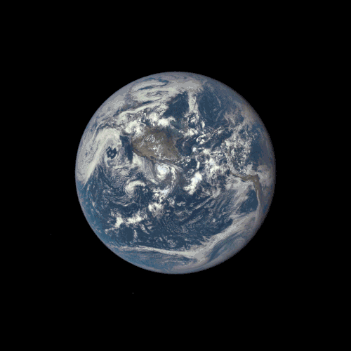
10. You can see a global image of your home planet…EVERY DAY

Once a day, we will post at least a dozen new color images of Earth acquired from 12 to 36 hours earlier. These images are taken by our EPIC camera from one million miles away on the Deep Space Climate Observatory (DSCOVR). Take a look HERE.
11. Employees of NASA have always been a mission driven bunch, who try to find answers that were previously unknown
The film “Hidden Figures,” focuses on the stories of Katherine Johnson, Mary Jackson and Dorothy Vaughan, African-American women who were essential to the success of early spaceflight.
Today, we embrace their legacy and strive to include everyone who wants to participate in our ongoing exploration. In the 1960’s, we were on an ambitious journey to the moon, and the human computers portrayed in Hidden Figures helped get us there. Today, we are on an even more ambitious journey to Mars. We are building a vibrant, innovative workforce that reflects a vast diversity of discipline and thought, embracing and nurturing all the talent we have available, regardless of gender, race or other protected status. Take a look at our Modern Figures HERE.
12. A lot of NASA-developed tech has been transferred for use to the public
Our Technology Transfer Program highlights technologies that were originally designed for our mission needs, but have since been introduced to the public market. HERE are a few spinoff technologies that you might not know about.
13. If all else fails, here’s an image of what we (Earth) and the moon look like from Mars

From the most powerful telescope orbiting Mars comes a new view of Earth and its moon, showing continent-size detail on the planet and the relative size of the moon. The image combines two separate exposures taken on Nov. 20 by our High Resolution Imaging Science Experiment (HiRISE) camera on our Mars Reconnaissance Orbiter.
In the image, the reddish feature near the middle of the face of Earth is Australia.
More Posts from Nasa and Others

http://bit.ly/rawcuriosity
Take a look around Mars. Here’s where I’m working right now.
Click the link to see all my latest pictures from the surface of Mars.
Astronaut Journal Entry - Alarms
Currently, six humans are living and working on the International Space Station, which orbits 250 miles above our planet at 17,500mph. Below you will find a real journal entry, written in space, by NASA astronaut Scott Tingle.
To read more entires from this series, visit our Space Blogs on Tumblr.

The smoke detectors have been setting off alarms. This happens routinely due to dust circulating in the modules, but every alarm is taken seriously. This is the third time that the alarm has sounded while I was using the Waste & Hygiene Compartment (toilet). I am starting to think that my actions are causing the alarms…. maybe I should change my diet?
Find more ‘Captain’s Log’ entries HERE.
Follow NASA astronaut Scott Tingle on Instagram and Twitter.
Make sure to follow us on Tumblr for your regular dose of space: http://nasa.tumblr.com.

Spacewalk complete and new astronaut record set! Shane Kimbrough and Peggy Whitson of NASA successfully reconnected cables and electrical connections on an adapter-3 that will provide the pressurized interface between the station and the second of two international docking adapters to be delivered to the complex to support the dockings of U.S. commercial crew spacecraft in the future. The duo were also tasked with installing four thermal protection shields on the Tranquility module of the International Space Station.
Having completed her eighth spacewalk, Whitson now holds the record for the most spacewalks and accumulated time spacewalking by a female astronaut. Spacewalkers have now spent a total of 1,243 hours and 42 minutes outside the station during 199 spacewalks in support of assembly and maintenance of the orbiting laboratory.
Astronaut Thomas Pesquet of ESA posted this image and wrote, ' Shane and Peggy on their way to their first #spacewalk tasks.'
Credit: ESA/NASA
Six Things You Need to Know About the Green Propellant Infusion Mission
Next week, we’re launching a new “green” fuel to space for the first time! The Green Propellant Infusion Mission (GPIM)—which consists of a non-toxic liquid, compatible propulsion system and the small satellite it’s riding on—will demonstrate how our technology works so that future missions can take advantage of this safer, more efficient fuel alternative.

Here are six key facts to know about our Green Propellant Infusion Mission:
1) The Air Force Research Lab developed the “green” fuel.
The AFRL’s hydroxyl ammonium nitrate fuel/oxidizer blend—called AF-M315E—is actually peach in color. This liquid doesn’t require the kind of strict, handling protocols that conventional chemicals currently require. Think shirtsleeves instead of hazmat suits, which could reduce pre-launch ground processing time for a spacecraft from weeks to days!

Image Credit: Air Force Research Lab
2) It’s safer and more efficient.
The non-toxic fuel offers nearly 50% better performance when compared to today’s highly toxic chemical propellant, hydrazine. That’s equivalent to getting 50% more miles per gallon on your car. This means spacecraft can travel farther or operate for longer with less propellant in their fuel tanks.

3) The fuel can handle extreme temperatures.
Even on missions to extremely cold environments, such as the south pole of Mars – where temperatures can dip as low as -225 degrees Fahrenheit and carbon-dioxide ice “spiders” can form (see below) – AF-M315E won’t freeze, but rather just transforms into a glass transition phase. This means even though it turns into a solid, it won’t cause spacecraft components to stretch or expand, so the spacecraft only has to warm up the fuel when it needs it.

4) Industry is already lining up to use the technology.
Our commercial partners report that there is a lot of interest and potential for this tech. After we successfully prove how it works in space, small satellites to large spacecraft could benefit by using the green propellant system. It’d only be a matter of time before companies begin building the new systems for market.

5) GPIM required a team of talented engineers.
Engineers at Aerojet Rocketdyne in Redmond, Washington developed new, optimized hardware like thrusters, tanks, filters and valves to work with the green fuel. GPIM uses a set of thrusters that fire in different scenarios to test engine performance and reliability.

Ball Aerospace of Boulder, Colorado designed and built the mini fridge-sized spacecraft bus and pieced it all together.

Before being ready for flight, GPIM components went through rigorous testing at multiple NASA centers including our Glenn Research Center, Goddard Space Flight Center and Kennedy Space Center. The program team at Marshall Space Flight Center manages the mission. Once in orbit, researchers will work together to study how the fuel is performing as they manipulate the spacecraft. The demonstration mission will last about 13 months.
6) GPIM will hitch a ride on a SpaceX Falcon Heavy rocket.
SpaceX’s Falcon Heavy rocket will launch for a third time for the U.S. Department of Defense’s Space Test Program-2 (STP-2) mission targeted for June 24, 2019 at 11:30 p.m. EDT. With nearly two dozen other satellites from government, military and research institutions, GPIM will deploy within a few hours after launch from NASA’s Kennedy Space Center in Florida. The SpaceX Falcon Heavy launch will be live-streamed here: https://www.nasa.gov/live

Follow @NASA_Technology on Twitter for news about GPIM’s launch.
Make sure to follow us on Tumblr for your regular dose of space: http://nasa.tumblr.com.
Welcome to the new, official NASA Tumblr. We’re going to be giving you a regular dose of space here. Follow along and join us as we share information, images and video about our mission of exploration and discovery. First up, check out the moon photobombing Earth in this new animated gif. The far side of the moon, illuminated by the sun, is seen as it crosses between our 'EPIC' camera on the Deep Space Climate Observatory (DSCOVR) satellite, and the Earth - one million miles away. Check it out: http://go.nasa.gov/1Dq0IO9
Solar System: 10 Things to Know This Week
State of the Solar System: 10 quick updates from around our galactic neighborhood.
1. Powered by the Sun

Fifty-nine years ago, Vanguard 1 launched to demonstrate a new spacecraft technology – solar power. We’ve been going farther and for longer ever since.
+More on Vanguard 1
2. Mapping Mercury

A big week in history for exploration of the innermost planet. On March 16, 1975, our Mariner 10 made its third and final flyby of Mercury. One day and 36 years later, MESSENGER became the first spacecraft to orbit Mercury. Next up: ESA’s BepiColumbo, undergoing testing now, is set to launch for Mercury in 2018.
+Missions to Mercury
3. Return to Venus

U.S. and Russian scientists are discussing a planned revival of the successful Venera program that revealed much about Venus in the 1960s, 70s and 80s. Meanwhile, Japan’s Akatsuki orbiter continues to study our sister planet.
+More on Venera-D
4. Rocket Power

Back on Earth 91 years ago (March 16, 1926), inventor and dreamer Robet Goddard changed the world forever with the first test of a liquid-fueled rocket. We’ve been going farther and faster ever since.
+More on Goddard
5. Moon Watch

Our Lunar Reconnaissance Orbiter (LRO) has been sending a steady stream of high-resolution images back to Earth for more than seven years.
+More on LRO
6. Busy Mars

There are currently five orbiters (Mars Reconnaissance Orbiter, Mars Odyssey, MAVEN, ESA’s Mars Express and India’s Mars Orbiter Mission) and two rovers (Curiosity and Opportunity) exploring Mars, making it second only to Earth in the number of robotic spacecraft studying its secrets.
+Meet the Mars Fleet
7. Vote for Jupiter

Polls close today (March 20) so vote not to point a real spacecraft camera at Jupiter during the mission’s 5th perijove pass.
+Vote now
8. Science to the Last Second

In a little less than six months, our Cassini orbiter will plunge into Saturn as a spectacular finale to its 19-year mission – but not before it embarks on a completely new mission into unexplored space between Saturn and its mighty rings.
+More on Cassini’s Grand Finale
9. By George?

Happy belated birthday to Uranus, discovered on March 13, 1781 by William Herschel. The English astronomer wanted to name his discovery – the first planet discovered in recorded history – “Georgium Sidus” after England’s King George III. But he was overruled, and astronomer stuck with traditional mythological names – creating an opportunity for 263 years of student jokes at the expense of the ice giant planet’s name.
+More on Uranus
10. Go Farther

The round trip light time from Voyager 1 to Earth is more than 38 hours. Voyager 1 is almost 13 billion miles from our home planet.
+More on Voyager
Discover more lists of 10 things to know about our solar system HERE.
Make sure to follow us on Tumblr for your regular dose of space: http://nasa.tumblr.com
NASA and Star Trek
Star Trek debuted in September 1966 and in its various incarnations, the series has been an inspiration to many, even some of us at NASA. The series allowed its fans to explore “strange new worlds” and to dream of what could be right in their living rooms. To celebrate the show’s 50th anniversary, we’ve collected some Trek-themed photos featuring Star Trek cast members and NASA astronauts.
Serious Business

The STS-54 crew of the space shuttle Endeavour in their official "gag" photo are costumed as the bridge crew of the Enterprise as depicted in the movie "Star Trek II: The Wrath of Khan.” The photo was taken on the Star Trek Adventure set of the Universal Studios California theme park in Los Angeles, California, while the crew was on a west coast training and public relations tour during the Summer of 1992. From left to right:
Greg Harbaugh (Mission Specialist/Engineering Officer)
Mario "Spock" Runco Jr. (Mission Specialist/1st Officer/Science Officer)
John Casper (Commander/Captain)
Susan Helms (Mission Specialist/Communications Officer)
Don McMonagle (Pilot/Navigation-Helm Officer)
“I have been, and always shall be, your friend”

Astronaut John Creighton shows the on board Graphical Retrieval Information Display (GRID) computer, which displays a likeness of Mr. Spock aboard STS-051G, June 18, 1985.
“A Keyboard. . . How Quaint”

Actor James Doohan (who played engineering genius Montgomery Scott in Star Trek) sits in the commanders seat of the Full Fuselage Trainer while astronaut Mario Runco explains the control panel during a tour of Johnson Space Center on Jan. 18, 1991.
“You Wanted Excitement, How's Your Adrenaline?”

Actress Nichelle Nichols (Uhura in Star Trek) toured Johnson Space Center in Houston on March 4, 1977, while Apollo 12 lunar module pilot and Skylab II commander Alan Bean showed her what it felt like inside the Lower Body Negative Pressure Device and showed her how the Shuttle Procedures Simulator operated.


Nichols paid us another visit in 2012 and 2015 with the Space Traveling Museum.
Infinite Diversity, Infinite Combinations

European Space Agency astronaut Samantha Cristoforetti gave the Vulcan salute aboard the International Space Station shortly after the passing of Leonard Nimoy on Feb. 28, 2015. She commented on Tweeter: " ‘Of all the souls I have encountered.. his was the most human.’ Thx @TheRealNimoy for bringing Spock to life for us"
Live Long And Prosper

While visiting Johnson Space Center in Houston, TX, George Takei (Hikaru Sulu on the original series) had the chance to exchange Vulcan salutes with Robonaut on May 29, 2012.
“Let’s See What’s Out There”

Scott Bakula, who played Captain Jonathan Archer on Star Trek: Enterprise, stands with astronauts Terry Virts and Mike Fincke on set. The two astronauts made guest appearances on the series finale episode “These Are The Voyages . . .” March 2005.
Boldly Going For Real

Above is the crew of STS-134, the next to last shuttle mission, in their version of the 2009 Star Trek movie poster.

The crew of Expedition 21 aboard the International Space Station also made a Trek-themed poster in 2009, wearing uniforms from Star Trek: The Next Generation with the Enterprise NX-01 silhouette in the background.
Learn more about Star Trek and NASA.
Make sure to follow us on Tumblr for your regular dose of space: http://nasa.tumblr.com
Solar System: 5 Things to Know This Week
From Mars to the asteroid belt to Saturn, our hardworking space robots are exploring the solar system. These mechanical emissaries orbit distant worlds or rove across alien landscapes, going places that are too remote or too dangerous for people (for now).
We often show off the pictures that these spacecraft send home, but this week we’re turning that around: here are some of the best pictures of the space robots, taken by other robots (or themselves), in deep space.
1. So Selfless with the Selfies

The Mars Curiosity rover makes breathtaking panoramas of the Martian landscape — and looks good doing it. This mission is famous for the remarkable self portraits of its robotic geologist in action. See more Martian selfies HERE. You can also try this draggable 360 panorama HERE. Find out how the rover team makes these images HERE.
2. Two Spaceships Passing in the Moonlight

In a feat of timing on Jan. 14, 2014, our Lunar Reconnaissance Orbiter caught a snapshot of LADEE, another robotic spacecraft that was orbiting the moon at the time. LADEE zoomed past at a distance of only about five miles below.
3. Bon Voyage, Galileo

The history-making Galileo mission to Jupiter set sail from the cargo bay of another spacecraft, Space Shuttle Atlantis, on Oct. 18, 1989. Get ready for Juno, which is the next spacecraft to arrive at Jupiter in July.
4. Cometary Close-Up

Using a camera on the Philae lander, the Rosetta spacecraft snapped an extraordinary self portrait at comet 67P/Churyumov-Gerasimenko from a distance of about 10 miles. The image captures the side of Rosetta and one of its 14-meter-long solar wings, with the comet in the background. Learn more about Rosetta HERE.
5. Man and Machine

This snapshot captures a remarkable moment in the history of exploration: the one and only time a human met up in space with a robotic forerunner on location. The Surveyor 3 lander helped pave the way for the astronaut footsteps that came a few years later. See the story of Apollo 12 and this unique encounter HERE.
Want to learn more? Read our full list of the 10 things to know this week about the solar system HERE.
Make sure to follow us on Tumblr for your regular dose of space: http://nasa.tumblr.com
The California Wildfires from Above
As massive wildfires continue to rage in southern California, our satellites, people in space and aircraft are keeping an eye on the blazes from above.
This data and imagery not only gives us a better view of the activity, but also helps first responders plan their course of action.

A prolonged spell of dry weather primed the area for major fires. The largest of the blazes – the fast-moving Thomas fire in Ventura County – charred more than 65,000 acres.

Powerful Santa Ana winds fanned the flames and forecasters with the LA office of the National Weather Service warned that the region is in the midst of its strongest and longest Santa Ana wind event of the year.
These winds are hot, dry and ferocious. They can whip a small brush fire into a raging inferno in just hours.

Our Aqua satellite captured the above natural-color image on Dec. 5. Actively burning areas are outlined in red. Each hot spot is an area where the thermal detectors on the satellite recognized temperatures higher than the background.

On the same day, the European Space Agency’s Sentinel-2 satellite captured the data for the above false-color image of the burn scar. This image uses observations of visible, shortwave infrared and near infrared light.

From the vantage point of space, our satellites and astronauts are able to see a more comprehensive view of the activity happening on the ground.

The crew living and working 250 miles above Earth on the International Space Station passed over the fires on Dec. 6. The above view was taken by astronaut Randy Bresnik as the station passed over southern California.

During an engineering flight test of our Cloud-Aerosol Multi-Angle Lidar (CAMAL) instrument, a view from our ER-2 high-altitude research aircraft shows smoke plumes. From this vantage point at roughly 65,000 feet, the Thomas Fire was seen as it burned on Dec. 5.

Our satellites can even gather data and imagery of these wildfires at night. The above image on the right shows a nighttime view of the fires on Dec. 5.
For comparison, the image on the left shows what this region looked like the day before. Both images were taken by the Suomi NPP satellite, which saw the fires by using a special “day-night band” to detect light in a range of wavelengths from green to near-infrared and uses light intensification to detect dim signals.

Having the capability to see natural disasters, like these wildfires in southern California, provides first responders with valuable information that helps guide their action in the field.
For more wildfire updates, visit: nasa.gov/fires.
Make sure to follow us on Tumblr for your regular dose of space: http://nasa.tumblr.com.
From Microscopic to Multicellular: Six Stories of Life that We See from Space
Life. It's the one thing that, so far, makes Earth unique among the thousands of other planets we've discovered. Since the fall of 1997, NASA satellites have continuously and globally observed all plant life at the surface of the land and ocean. During the week of Nov. 13-17, we are sharing stories and videos about how this view of life from space is furthering knowledge of our home planet and the search for life on other worlds.

Earth is the only planet with life, as far as we know. From bacteria in the crevices of the deepest oceans to monkeys swinging between trees, Earth hosts life in all different sizes, shapes and colors. Scientists often study Earth from the ground, but some also look to our satellites to understand how life waxes and wanes on our planet.
Over the years, scientists have used this aerial view to study changes in animal habitats, track disease outbreaks, monitor forests and even help discover a new species. While this list is far from comprehensive, these visual stories of bacteria, plants, land animals, sea creatures and birds show what a view from space can reveal.
1. Monitoring the single-celled powerhouses of the sea

Known as the grass of the ocean, phytoplankton are one of the most abundant types of life in the ocean. Usually single-celled, these plant-like organisms are the base of the marine food chain. They are also responsible for the only long-term transfer of carbon dioxide from Earth’s atmosphere to the ocean.
Even small changes in phytoplankton populations can affect carbon dioxide concentrations in the atmosphere, which could ultimately affect Earth’s global surface temperatures. Scientists have been observing global phytoplankton populations continuously since 1997 starting with the Sea-Viewing Wide Field-of View Sensor (SeaWiFS). They continue to study the small life-forms by satellite, ships and aircrafts.
2. Predicting cholera bacteria outbreaks
Found on the surface of zooplankton and in contaminated water, the bacteria that cause the infectious disease cholera — Vibrio cholerae — affect millions of people every year with severe diarrhea, sometimes leading to death. While our satellite sensors can’t detect the actual bacteria, scientists use various satellite data to look for the environmental conditions that the bacteria thrive in.
Specifically, microbiologist Rita Colwell at the University of Maryland, College Park, and West Virginia University hydrologist Antar Jutla studied data showing air and ocean temperature, salinity, precipitation, and chlorophyllconcentrations, the latter a marker for zooplankton. Anticipating where the bacteria will bloom helps researchers to mitigate outbreaks.

Recently, Colwell and Jutla have been able to estimate cholera risk after major events, such as severe storms, by looking at satellite precipitation data, air temperature, and population maps. The two maps above show the team's predicted cholera risk in Haiti two weeks after Hurricane Matthew hit over October 1-2, 2016 and the actual reported cholera cases in October 2016.
3. Viewing life on land
From helping preserve forests for chimpanzees to predicting deer population patterns, scientists use our satellites to study wildlife across the world. Satellites can also see the impacts of perhaps the most relatable animal to us: humans. Every day, we impact our planet in many ways including driving cars, constructing buildings and farming – all of which we can see with satellites.

Our Black Marble image provides a unique view of human activity. Looking at trends in our lights at night, scientists can study how cities develop over time, how lighting and activity changes during certain seasons and holidays, and even aid emergency responders during power outages caused by natural disasters.
4. Tracking bird populations
Scientists use our satellite data to study birds in a variety of ways, from understanding their migratory patterns, to spotting potential nests, to tracking populations. In a rather creative application, scientists used satellite imagery to track Antarctica’s emperor penguin populations by looking for their guano – or excrement.

Counting emperor penguins from the ground perspective is challenging because they breed in some of the most remote and cold places in the world, and in colonies too large to easily count manually. With their black and white coats, emperor penguins are also difficult to count from an aerial view as they sometimes blend in with shadows on the ice. Instead, Phil Trathan and his colleagues at the British Antarctic Survey looked through Landsat imagery for brown stains on the sea ice. By looking for penguin droppings, Trathan said his team identified 54 emperor penguin colonies along the Antarctic coast.
5. Parsing out plant life
Just as we see plants grow and wilt on the ground, satellites observe the changes from space. Flourishing vegetation can indicate a lively ecosystem while changes in greenery can sometimes reveal natural disasters, droughts or even agricultural practices. While satellites can observe plant life in our backyards, scientists can also use them to provide a global picture.

Using data from satellites including SeaWiFS, and instruments including the NASA/NOAA Visible Infrared Imaging Radiometer Suite and the Moderate Resolution Imaging Spectroradiometer, scientists have the most complete view of global biology to date, covering all of the plant life on land and at the surface of the ocean.
6. Studying life under the sea
Our satellites have helped scientists study creatures living in the oceans whether it’s finding suitable waters for oysters or protecting the endangered blue whale. Scientists also use the data to learn more about one of the most vulnerable ecosystems on the planet – coral reefs.

They may look like rocks or plants on the seafloor, but corals are very much living animals. Receiving sustenance from photosynthetic plankton living within their calcium carbonate structures, coral reefs provide food and shelter for many kinds of marine life, protect shorelines from storms and waves, serve as a source for potential medicines, and operate as some of the most diverse ecosystems on the planet.

However, coral reefs are vulnerable to the warming of the ocean and human activity. Our satellites measure the surface temperature of ocean waters. These measurements have revealed rising water temperatures surrounding coral reef systems around the world, which causes a phenomenon known as “coral bleaching.” To add to the satellite data, scientists use measurements gathered by scuba divers as well as instruments flown on planes.
During the week of Nov. 13-17, check out our stories and videos about how this view of life from space is furthering knowledge of our home planet and the search for life on other worlds. Follow at www.nasa.gov/Earth.
Make sure to follow us on Tumblr for your regular dose of space: http://nasa.tumblr.com.
-
 recaisblog liked this · 3 years ago
 -
 confirmedworm liked this · 4 years ago
 -
 ricko1994 liked this · 6 years ago
 -
 howaboutwegetlost liked this · 6 years ago
 -
 pankratz liked this · 7 years ago
 -
 cetpar liked this · 7 years ago
 -
 shellumbo reblogged this · 7 years ago
 -
 just-a-gay-trans-kid-blog reblogged this · 7 years ago
 -
 please-dont-attack-me liked this · 7 years ago
 -
 thenorthernlytes liked this · 7 years ago
 -
 umbreonpanda liked this · 8 years ago
 -
 notsureifunsure reblogged this · 8 years ago
 -
 gallifreyan-magics reblogged this · 8 years ago
 -
 mesothelioma-lawyers-blog1 liked this · 8 years ago
 -
 youarenothem reblogged this · 8 years ago
 -
 starwarshero45 liked this · 8 years ago
 -
 jazminopoodlekins liked this · 8 years ago
 -
 undeadratmother-blog reblogged this · 8 years ago
 -
 nocoastmilly reblogged this · 8 years ago
 -
 gayroadkill liked this · 8 years ago
 -
 mittensfelicityromney liked this · 8 years ago
 -
 jenakajiwa-blog liked this · 8 years ago
 -
 thestorycontinues liked this · 8 years ago
 -
 tired-science-nerd reblogged this · 8 years ago
 -
 defender-of-wilderness liked this · 8 years ago
 -
 fr0mtheashes95 reblogged this · 8 years ago
 -
 roaragainstallwar reblogged this · 8 years ago
 -
 unidentifiedanonfics liked this · 8 years ago
 -
 academiclemonade reblogged this · 8 years ago
 -
academiclemonade liked this · 8 years ago
-
 unofficial-cactus reblogged this · 8 years ago
 -
 or2dosomethingaboutit reblogged this · 8 years ago
 -
 sodapop000 reblogged this · 8 years ago
 -
sodapop000 liked this · 8 years ago
-
 hippy-dippy-doo-420-blog reblogged this · 8 years ago
 -
hippy-dippy-doo-420-blog liked this · 8 years ago
Explore the universe and discover our home planet with the official NASA Tumblr account
1K posts